BONNIE DOON TRACK, KATOOMBA
BLUE MOUNTAINS NSW AUSTRALIA
 |
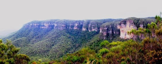
| View of Nellie's Glen from North's Lookout |
The area known as “Bonnie
Doon” lies on the western side of
Katoomba, south of the “Explorers' Tree” and adjacent to Nellie’s Glen. There have been tracks
through this area since the 19th century, though the present day one
appears to have been constructed about 25 years ago, judging from its
deteriorating condition. Today’s track seems to be in a different location from
those shown on old maps.
The track basically runs between two lookouts (North’s and
Therabulat) crossing several minor streams as it winds through bush land. Sadly,
there are no views of the cascades and waterfalls which the walker can hear
further down the valleys. It is as if the track has been constructed in the
most economical way possible to connect two points while staying away from the
more difficult places, which no doubt are the very ones the walker would like
to see.


It is possible to see the lowermost of the so-called Bonnie Doon Falls from Peckman’s
Plateau Lookout, on the cliff top south of Therabulat Lookout (see my video here)
or from a track which leaves the Six Foot track in Nellie’s Glen. This is the
fall identified as Ethel Fall in early accounts of the locality. The other
falls (3, according to the 1909 map illustrated) remain hidden from view.
Access to the area is from the Nellie’s Glen car park (just
past where the Explorers' Tree used to be), turn left off the highway), which takes you down to North’s Lookout and from the end of
Stuart’s Road, off Cliff Drive. This leads to Therabulat Lookout (take a left branch). Either way, if you
 |
| The view from Therabulat Lookout to Megalong Valley |
continue far enough along the track, you will encounter a newly constructed
track coming from who knows where (no signpost in March 2014). Why this track
has been pushed through a declared Fauna Study Area (thus destroying hundreds
of thousands of native plants) is anyone’s guess.
The other disturbing feature of the walk is the evidence
which remains around Nellie’s Glen of the environmental damage caused when an
attempt was made to construct a fire trail down the Glen some years ago. One
could be excused for thinking that the powers-that-be are less concerned about
the scenic and conservation values of this part of Katoomba than they are, say,
of those around Katoomba Falls and Echo Point. When you read old newspaper
accounts of Bonnie Doon you will soon discover that this has always been an
area which has suffered from the hands of timber getters, wild flower pickers,
bush rock gatherers and the like. It is an attractive and interesting place and
deserves to be better appreciated.
 |
| From a 1905 guide book |
There are many accounts of walks in this area. Simply Google
“Bonnie Doon” Katoomba to come up with a list. My video on Bonnie Doon is here and the one on Peckman’s Plateau is here.
https://johnsbluemountainsblog.blogspot.com/2013/12/links-to-all-blog-entries-and-relevant.html All Blue Mountains blogs and videos
All New England and other Geology blogs and videos
Limestone Caves of NSW
Song Studies. Bible studies based on hymns and songs
Shoalhaven District Geology
 |
| The top of Ethel Fall from North's Lookout |
 |
| Yellow Tailed Black Cockatoo |