Search This Blog

Showing posts with label view. Show all posts

Friday, 24 January 2014

PRINCE HENRY CLIFF WALK: KATOOMBA CASCADES TO ECHO POINT

PRINCE HENRY CLIFF WALK: 
KATOOMBA CASCADES TO ECHO POINT

Cliff View Lookout
The Prince Henry Cliff Walk was named for Prince Henry, Duke of Gloucester, third son of King George V. He neither saw the track nor opened it, but was “in the right place at the right time” (so to speak). He was visiting Australia in 1934 when the first stage of the track was opened. It was a popular thing in those days to name places after royalty and the Duke happened to be the chosen one this time. You can see a photograph of the Duke at Katoomba Station by clicking here.

When he returned to Australia in 1945 to serve as Governor-General he was well received; by this time he was the brother of the king, George VI. The royal family had become very popular during  the war because of their support for the people of England who suffered so much, particularly during the Blitz.

Sphinx Rock
Sydney Morning Herald
The section of the Walk from Katoomba Falls to Leura Cascades was opened at Echo Point by the Minister for Local Government, Mr ES Spooner. It is one of a number of enterprising tourist paths opened around the same time – the Orphan Rock ascent, the Giant Stairway and the Projecting Platform at Echo Point being the others. Coupled with the new floodlighting, the Cliff Drive and the development of the Scenic Railway, this must have been a boom time for Katoomba!

Before the track was developed there were already a number of popular spots along the route: the Katoomba Cascades, Cliff View Lookout, The Sphinx rock, Lady Darley Lookout and Echo Point. Now it was possible to get a bus to either end and walk between the two in less than hour. Lots of people do this every day, just as they have been doing for the past 80 years. You have lots of options when it comes to returning to your starting point. I decided to follow the road and rejoin the walk at the Skyway terminal near Cliff View Lookout. 

Callicoma (black wattle)

The area before the Cliff Walk was constructed
My video of the walk is here. 

The area in 1952 (much the same today)


Friday, 3 January 2014

THE BRAESIDE WALK, BLACKHEATH BLUE MOUNTAINS NSW AUSTRALIA

THE BRAESIDE WALK, BLACKHEATH 

BLUE MOUNTAINS NSW AUSTRALIA

This beautiful walk is not one with a long pedigree, no mention being made of it in any publication I can find before 1946. It is shown on a map of 1935 as “Walk to Govett’s Leap”. 

There are several possible access points: (a) from Govett’s Leap Lookout, by taking the Cliff Top walk down to the crossing over Govett’s Leap Brook, where the northern end of the track begins. (b) by following the power line tracks from near Connaught Rd and Cleopatra St. and (c) from James Rd, which is a gravel road leaving Braeside St near Bell St. going through to Evan’s Lookout Rd. This crosses Govett’s Leap Brook just above the old railway dam; the southern access to the track is nearby. A parking area and a small picnic area are located here, making it the simplest access point to the walk, which basically follows the creek down to the brink of Govett’s Leap. James Rd, however, is often regarded as a 4 wheel drive road.

Govett's Leap Brook crossing
Braeside is an appropriate name, meaning approximately “the bank of a creek”. The name of the street is identical to several older cottages in Blackheath, none of which were actually in the present street of that name. Braeside St is the obvious source of the name of the walk and it appears to have been named before 1920.
Robinson's 1952 map

The original water supply for the railway (steam engines use lots of it) was drawn from swamps in what is now the Memorial Park. Two dams were subsequently constructed here; however they proved inadequate as railway traffic increased and a dam was built on Govett’s Leap Brook in 1906. From here, water was pumped up to a reservoir in Whitley Park then fed by gravity to the railway station. This system was abandoned in 1927. The dam wall and brick and stone foundations remain.

My video on the walk is here. 
Railway dam and picnic area

                                     https://johnsbluemountainsblog.blogspot.com/2013/12/links-to-all-blog-entries-and-relevant.html All Blue Mountains blogs and videos
Shoalhaven District Geology  
                           

Saturday, 30 November 2013

STONEHAVEN PASS, WENTWORTH FALLS BLUE MOUNTAINS NSW AUSTRALIA

STONEHAVEN PASS, WENTWORTH FALLS 
BLUE MOUNTAINS NSW AUSTRALIA

Murphy's Spiral Lookout
I would not be surprised if most readers have never heard of “Stonehaven Pass”. I hadn’t, until I came across Jim Smith’s excellent article on the subject while searching the web for something else. You will find it here ; it will tell you all you would like to know about the Pass – the origin of the name, how it came be to be constructed, then neglected and now made accessible again. You will learn a lot about the Wentworth Falls Reserve Trust and the names given along this track to honour these men and those employed by them to construct and maintain the network of tracks and lookouts that make Wentworth Falls such a great place to visit today. * Unfortunately Jim Smith's article has been removed from the Web since this blog was written.

Photo from the State Library
 of Queensland
I doubt that Baron Stonehaven (Governor General of Australia 1925-1930) ever heard of this short walk now named after him. He certainly never came to Wentworth Falls as the Trustees hoped he would, nor did the pass become a popular walking track. In fact, it fairly quickly faded into obscurity (as did other tracks) as the years of the Depression and World War 11 rolled by and the changeover to management by, first of all the Blue Mountains City Council and then by the National Parks and Wildlife Service.

I started the walk from the Princes Rock track, from which it branches to the right as you descend, a little below the old well on the left. There is presently no sign post, but there is a National Parks sign soon after entering. If you are coming from the Den Fenella track, the turnoff is on the left a minute or so after you start down the hill. There is an identical sign at this end of the track, but nothing at the actual turnoff.                                                                               
See my video of the walk or study Jim Smith’s map (or both) to get an idea of the layout. The track is easy to follow, if a little wet in places (hanging swamps abound in this part of the National Park). The lookouts have the remains of the original fencing around their edges but they wouldn’t help you much if you slipped. It is definitely not a place for children unless they are closely supervised.

The men working on the Den Fenella track told me that they believed the Stonehaven Pass track was also going to be upgraded. Much as I enjoyed the walk the way it is, I guess that making it more accessible will allow more people to appreciate it. Meanwhile, thank you to those who did the work back in the 1920’s and those who reopened the track as it is today.

 My You Tube video of Stonehaven Pass may be found here .

Sunday, 17 November 2013

LEURA CASCADES, BLUE MOUNTAINS NEW SOUTH WALES AUSTRALIA

LEURA CASCADES

BLUE MOUNTAINS NEW SOUTH WALES AUSTRALIA

The Leura Cascades area is accessible from either Katoomba or Leura by the Cliff Drive. It came to prominence when the Katoomba swimming baths were constructed in 1913, but the area was already the focus for a number of popular walking tracks, notably those leading to the Federal Pass and the two Leura falls (commonly called the Bridal Veil (upper falls) and Leura Falls (lower). The legacy from those times is a great network of tracks providing lots of different routes commencing at the cascades picnic area (see the blog entry on this dated 5th October 2013).

Two significant events which have left their mark on the area were the decision to bring the Leura-Katoomba sewer pipes down into the Jamison Valley via this route and the floodlighting of the Cascades in 1932.

I have found it difficult to piece together the history of sewerage schemes in the upper Blue Mountains, but it would appear that Katoomba at least had a system operating by 1910. (Cast iron pipes alongside the Katoomba Falls valley walks are dated 1909.) A similar system probably operated via the Leura Falls Gap; both seem to have operated on a septic tank/filter bed system with the semi-purified effluent then being discharged into the creek. 

Newspaper reports show that the Leura Creek route was being considered for major augmentation in the following decade. The sewage treatment plant which eventuated was finally opened in 1935, only being replaced a few years ago by the deep drainage tunnel which takes sewage from the upper Blue Mountains by gravity down to the treatment works at Winmalee. See the “Sydney Morning Herald” (NSW: 1842 - 
From the SMH November 18 1935
1954), Monday 18 November 1935, page 8 (via “Trove”).

The Leura-Katoomba floodlighting was part of the major improvements to tourist facilities carried out during the Great Depression, which was vital in keeping people employed in those difficult times. The complete article about the opening makes good 
From the SMH December 5 1932
reading. See the “Sydney Morning Herald” (NSW: 1842 - 1954),  Monday 5 December 1932, page 9 (via “Trove”).

The floodlit Cascades August 1968
Just when the Leura Cascades lost its floodlights I don’t know, but the remains of posts and wires may still be seen beside the track. As you make your way from the picnic area down to the Bridal Veil Falls, you won’t notice these things because of the beauty of your surroundings. The removal of the sewer lines and the floodlights has brought the area closer to what it once must have been.                                
                                                           
For my video of the walk, click here . 
See the 2013 photo of the same location at the top of this page


From an album of Harry Phillips photos presented to Frederick John Spellacy dated 12 April 1935.
As an Alderman on Katoomba Municipal Council and local bus operator, John Spellacy was instrumental in the floodlighting of the Three Sisters and Leura Cascades, officially opened December 3, 1932.

Friday, 8 November 2013

BARROW LOOKOUT BLACKHEATH BLUE MOUNTAINS NSW AUSTRALIA

BARROW LOOKOUT BLACKHEATH 

BLUE MOUNTAINS NSW AUSTRALIA


Barrow Lookout from Govett's Leap Lookout
Barrow Lookout is easily seen from Govett’s Leap Lookout, being just to the left of the waterfall and above it, on the cliff top track to Evans Lookout. It takes its name from the 19th century surveyor Isaac Le Pipre Barrow, who worked in the area.

Its location matches the place mentioned by Assistant Surveyor William Romaine Govett in his letter to Surveyor General Major Thomas Mitchell dated 1st July 1831. “The Creek near ‘Blackheath’ after running about two miles and a half falls abruptly after the manner of the cascade at the ‘Weatherboard’ into one of the Gullies of the Grose River; at a point near this fall of water you have a grand view of two cascades, and that break of rock which forms such a particular (feature) in this Survey. Indeed I have not as yet seen a view which shews (sic) so well the character of the mountain feature …”. (Quoted from “Blackheath Today from Yesterday” p 131, edited by Peter C Rickwood and David J West, 2005).    
                                                                         
Govett's Leap from Barrow Lookout
No doubt Govett discovered the waterfall by following the creek we now know as Govett’s Leap Brook, rather than the ridge which ends with the present day Govett’s Leap Lookout. We need to take note at this point that the correct name for the waterfall is “Govett’s Leap” (not the Bridal Veil or Bridal Veil Falls), which name appears to have been given by Mitchell soon after Govett’s discovery. The monument at Govett’s Leap Lookout reads as follows: “This fall of water was named Govett’s Leap from the circumstance of William Romaine Govett Assistant Surveyor first having come upon the spot in June 1831”.

This concise statement of the facts is in stark contrast to the bizarre stories that abounded from the early 1870’s onwards, which had Govett as a bushranger, an escaped convict or convict overseer, a murderer and general vagabond. His “leap” was supposed to have been on horseback over a rocky gully (which he and his horse survived) or over the cliff (in which case they didn’t). Those responsible for promoting tourism in Blackheath could have easily contradicted these wild stories; however it seems that they used them to promote interest in the town and district. Even today poor Govett is seldom show the respect he deserves.

I don’t know when the name “Govett’s Leap” came into general use, but in the 1845 edition of Charles Darwin’s “The Voyage of the Beagle”, chapter 19 page 438 we read "Jan 18, 1836: Very early in the morning, I walked about three miles to see Govett's Leap: a view of a similar character with that near the Weatherboard, but perhaps even more stupendous.”
Not having seen Darwin’s original diary, I can’t say that he actually wrote this in 1836. Darwin corresponded with Major Thomas Mitchell and it is possible that he was given the name by him, inserting it into the text when he prepared his notes for publication. The name was certainly in common use when the railway opened to Mt Victoria on 1st May 1868. The first timetables suggest that the reason for trains stopping at Blackheath was so that visitors could go and see Govett’s Leap.
Readers might like to look up this reference in Trove: The World's News (Sydney, NSW: 1901 - 1955), Saturday 30 September 1922, page 20, 21.

Professor V. Gordon Childe
Now here is an intriguing story for readers of this blog to follow up. What happened to world renowned archaeologist, atheist and socialist Professor V. Gordon Childe at Barrow Lookout in 1957?

See the article by Dr Peter Rickwood in the “Blue Mountains History Journal”, Issue 3 October 2012 page 35. 


For my video on the walk from Govett's Leap Lookout to Barrow Lookout, click here. 


Tuesday, 22 October 2013

ANVIL ROCK, BLACKHEATH BLUE MOUNTAINS NEW SOUTH WALES AUSTRALIA

ANVIL ROCK, BLACKHEATH 

BLUE MOUNTAINS NEW SOUTH WALES AUSTRALIA

Anvil Rock is located on the edge of the Grose River gorge, about 7 km north of Blackheath. Access is via Hat Hill Road to the Blue Mountains National Park; the road and track to the Rock are clearly signposted. 

Anvil Rock was named because of its shape by the then Blackheath Municipal Council in 1938 when the present road was constructed. Ten years later, the steel anvil which is now attached to the top of the rock was first put in place. You can read the story of how this was done, how it was lost for more than 30 years and how it was reattached in 2008 here .

The walk from the car park takes less than 15 minutes and there are great views of the Grose River gorge both from the track and from Anvil Rock itself. The day I was last there was clear and fine and it was easy to zoom in and photograph the high rise buildings in the centre of Sydney.

Mt Banks August 1964
The views from Anvil Rock are superb, and the centrepiece is Mt Banks, which lies immediately opposite. The annotated photo below comes from “Layers of Time: The Blue Mountains and Their Geology” (DIGS reference GS1998/519). See the Blog entry on “DOWNLOADING PDF DOCUMENTS FROM DIGS”. You can readily identify the main strata, from the basalt cap down through the Triassic and into the Permian below. This is one of the best places in the Blue Mountains to see such a stratigraphic column of the Sydney Basin sedimentary rocks.

For the Wild Walks description of the Anvil Rock walk click here .

Here is a link to a 1950’s photo of the rock by celebrated photographer Frank Hurley.


Sunday, 20 October 2013

WENTWORTH FALLS, BLUE MOUNTAINS NEW SOUTH WALES AUSTRALIA

WENTWORTH FALLS

BLUE MOUNTAINS NEW SOUTH WALES AUSTRALIA


The Falls from Fletcher's Lookout November 2005
The waterfall we now know as Wentworth Falls may well have been sighted during the first European crossing of the Blue Mountains in 1813. The expedition had been following the ridge dividing the streams flowing north into the Grose River and those flowing south into the Nepean River (Glenbrook Creek, Bedford Creek etc). Their route brought them out onto the edge of King’s Tableland, south of the present day township of Wentworth Falls, forcing them to deviate to the north to get around the cliffs of what we now call the Jamison Valley.

Whether George Evans or William Cox saw the falls (1813-1815) I have been unable to establish, but as Governor Lachlan Macquarie’s party was taken out in 1815 to see the falls and the valley we must assume that they were already known by then. Macquarie named the falls “Campbell’s Cataract”, after his secretary John Thomas Campbell, who was actually his wife Elizabeth’s brother. The name “Jamison Valley” (various spellings) dates from this time, also “Prince Regent’s Glen” and “King’s Tableland”.           
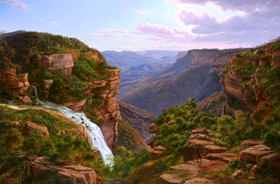
The Weatherboard Creek Falls. Eugene Von Guerard 1862
Despite Governor Brisbane renaming the falls to “Bougainville Falls” in 1825 to honour the leader of a French scientific expedition at that time, the public began to use the name “Weatherboard Falls”, after Cox’s 1814 weatherboard store hut built on Jamison Creek, upstream of the falls, and later the Weatherboard Inn, built 1826-29. Most travellers who could afford to stay at an inn stayed here, and many walked out to see the falls and the valley.

Charles Darwin recorded his visit in 1836 in his account of the voyage of the Beagle; he appears to have stayed at the Weatherboard Inn on his outward journey to Wallerawang and Bathurst and again on his return, walking to the falls on both occasions.
The Weatherboard Falls, Blue Mountains.
 JH Carse 1876
The name “Weatherboard Falls” began to be replaced by “Wentworth Falls” following the renaming of the railway station in 1879. The falls became the centrepiece of the reserve established there, formerly administered by a local trust, then by the Blue Mountains City Council and now by the National Parks and Wildlife Service. More will be said about this in a later blog entry.

Here are some useful sites you can visit. Firstly, from the Wild Walks site, covering the track to the top of the falls via Fletcher’s Lookout, then the Undercliff Track and finally the Princes Rock track here, here and here .

Wentworth Falls February 2013
The photograph of Wentworth Falls in extreme flood in February 2013 comes from this article here.

Here are two interesting videos. The first shows the falls in flood here and the second in strong wind here.  

Finally, my own You Tube site, which includes a video on a walk to the falls via Fletcher’s Lookout, returning via the Undercliff and Princes Rock tracks here . 

The two paintings illustrated are on display in the National Gallery of Victoria, Melbourne.


The Weeping Rock, Wentworth Falls. June 1958

Tuesday, 1 October 2013

PERRY’S LOOKDOWN, BLACKHEATH BLUE MOUNTAINS NEW SOUTH WALES AUSTRALIA

PERRY’S LOOKDOWN, BLACKHEATH 

BLUE MOUNTAINS NEW SOUTH WALES AUSTRALIA

Hat Hill Road at Blackheath leads out to several places where there are superb views over the valley of the Grose River and its tributaries. Among these is Perry’s Lookdown, a popular place with visitors since the 1880’s. There are three identified lookouts – Perry’s Lookdown itself, Docker’s Lookout and what has become known as Monument Lookout. Beyond the third lookout the track descends steeply into the valley, providing access to the Blue Gum Forest and the walking tracks which radiate from it.

You’ll enjoy reading an article from the Illustrated Sydney News (NSW: 1853 - 1872), Saturday 16 February 1884, page 14, 15 titled “Our Trip to Binda Caves” (now called Jenolan Caves) during which the party visited Perry’s Lookdown. Search the newspaper files at http://trove.nla.gov.au .                                                                 
Immediately opposite the main lookout is the dramatic Mt Banks, so named by George Caley in November 1804 in honour of his patron, Sir Joseph Banks, when his attempt to cross the Blue Mountains came to an end on the brink of those cliffs. See this reference here for more information about Caley’s expedition. The mountain is capped by a small area of basalt which has somewhat fortuitously preserved a remnant of the Hawkesbury Sandstone and a complete section of the underlying Narrabeen Group sediments of the Sydney Basin.
 
The National Parks and Wildlife Service has provided a rather scarce facility in the form of a small overnight camping area which is particularly useful for those doing the longer walks.
Monument Lookout is the site of memorial to a group of 4 teenagers who died in the vicinity in a bushfire in 1957. See the story in The Canberra Times (ACT : 1926 - 1995), Monday 2 December 1957, page 1.

View my Blue Mountains videos on my YouTube site here . This includes a video on the lookouts at Perry’s Lookdown here .