Search This Blog

Showing posts with label Trove. Show all posts

Friday, 10 June 2016

DOWNLOADING A 1955 BOOKLET: THE STORY OF MT WILSON IN THE BLUE MOUNTAINS

DOWNLOADING A 1955 BOOKLET: THE STORY OF MT WILSON IN THE BLUE MOUNTAINS

If you haven’t visited Mt Wilson yet, this 1955 tourist booklet will make you want to! You can download it from Trove here. If you have trouble finding it, try a search in the “Books” category, using “The Story of Mt Wilson in the Blue Mountains” in the search box, then following the prompts. The link to Trove is here.
You will be able to make more sense of the 1955 book if you have the modern information and map to locate many of the places mentioned.
Mt Wilson is a very special place, being a fertile, elevated piece of land in the sandstone wilderness of Wollemi National Park. I have made several videos and blogs on Mt Wilson already and I am hoping to do more.
St Basil's Church Mt Wilson 1953
Here is a list:
The Waterfall Track here.
Wynne’s Rocks and Du Faur’s Rocks Lookouts here.
The Cathedral Reserve here.
Blog: The Geology of Mt Wilson here.
I’ve also made a slide show using the illustrations from The Story of Mt Wilson (here).
At Wynne's Rocks Lookout 2014

Tuesday, 9 June 2015

DOWNLOAD A COPY OF “THE MOUNTAINEER” (1908) BLUE MOUNTAINS TOURIST GUIDE

DOWNLOAD A COPY OF “THE MOUNTAINEER” (1908) BLUE MOUNTAINS TOURIST GUIDE

Over the past 150 years (or thereabouts) hundreds, maybe thousands, of books have been written about the Blue Mountains of NSW, Australia. Their location (50-100 km west of Sydney), their wild beauty (rugged sandstone outcrops, numerous waterfalls and cascades), their vegetation and their altitude (rising to more than 1100 metres ASL) have made the area a popular place to visit and live.
More books are being written even as I write this which shows the undying interest of the public in “all things Blue Mountains”. While the occasional copy of an out-of print book can be found in second hand shops, I know from experience how rarely this happens. Even then it is unlikely to be as much as 50 years old. However, there is a resource available to all where we can download (for free!) copies of some genuinely old books. I am referring, of course, to Trove, the online arm (eye might be better) of the National Library of Australia. You can go to the Trove site directly from this link here. You will soon discover that it is a very diverse collection indeed. If you are new to Trove, I suggest you spend some time exploring it. You will be amazed at what’s there for you to study and enjoy.
I’ve chosen to concentrate on collecting downloadable books, magazines etc which deal directly with the Blue Mountains, though I have built up quite a library of other material which interests me. Getting time to read this electronic library is another thing, however!
You will generally be able to get what you want as a .pdf file, something easily read, saved and passed on to others. Sometimes it will come as an html file, which can present a problem if you are trying to make your collection look neat. It won’t always be easy to find out exactly how to download the desired item, but you can’t do any harm to the original by trying.
Even if you select “available online”, that doesn’t mean you can download the file or even look at it. You may need to be a member of a particular library (which means having a password) or be able to see only a page at a time. That’s all part of the challenge, I guess.
Finally, you will locate lots of material you can’t download. Usually this means that it is still covered by copyright; in these cases you may be able to locate a library from which a hard copy can be borrowed.
The reference in question today is the 1908 printing of “The Mountaineer”  the Blue Mountains tourist guide book. You can experiment by locating it yourself or you can use this link which I’ve already found here. This takes you to an information page. Here there are a number of active links which lead you to another information page. One of these is the image of the cover of the book, which is the one I followed. This second information page also has an image of the cover; clicking on this takes you to a third information page. On the left margin is a series of buttons, one of which (a down arrow in a circle) brings up “download” when the cursor passes over it. Click on it, and yet another information page appears. It is preset on .pdf for me, if not, select it, followed (finally) by "download”.

What you do now is going to depend on what software you have, but I select “Save File”, which puts a copy of the document into my download folder. Later on, I can shift it to a permanent folder, adjusting the name to whatever suits me. If I select “Open” instead, a copy of the document opens on the screen (naturally). You can then save it to wherever you wish.
This blog is illustrated by pages from the book, which, incidentally, is physically very small and fits into the palm of your hand. I have a 1927 copy, passed on from my maternal grandmother. Most of the text is the same as the 1908 version, though many of the advertisements, maps and other information have been updated.
Much of this material is repeated in my video on the same subject. You can view it by clicking here.


Wednesday, 29 January 2014

HASSAN’S WALLS LITHGOW WESTERN BLUE MOUNTAINS

HASSAN’S WALLS LITHGOW 
WESTERN BLUE MOUNTAINS

Anyone driving on the Great Western Highway between Hartley and Lithgow will have noticed the cliffs of Hassan’s Walls above them. They are outliers of the same Triassic sandstone familiar to everyone in the western Blue Mountains.
Like Govett of Govett’s Leap at Blackheath, people ask “Who was Hassan?” Answers will vary: he was an escaped convict (there was a convict stockade below the Walls in the early days), he was a character in the Arabian Nights, he was an Arab stockman.
The right answer seems to be that Governor Lachlan Macquarie named the Walls during his trip to Bathurst in 1815 on the newly built Cox’s Road. It is said that they reminded him of the Walls of Hassan in southern India, but whether this is true or not I cannot say. However the name came to be given, it has certainly stuck.                                                                                                                               
1895 newspaper quote
The Walls have always been a tourist attraction to visitors and the people of Lithgow. The area was made a Reserve as long ago as 1895; however it was the work of James Padley during World War 1 that laid the foundation for the Reserve as we see it today. Even a brief look at Trove (newspaper files) reveals the extent of the problems – vandalism, littering, stealing native plants
Illustrated Sydney News February 7th 1889
and just general apathy. Nor have these problems ceased in the district. The Zig Zag Railway has been suffering from constant vandalism and theft for years, most likely carried out by local residents, perhaps the descendants of the Hassan’s Walls vandals of earlier years.
Lithgow City Council is in the process of having a boardwalk, interpretive signs etc constructed right now (January 2014). No doubt these will be great assets and improve the visitor’s experience greatly. However, history shows that the graffiti “artists”, vandals and thieves won’t take long to get up there to try to spoil that experience.
The area has an incredibly varied fauna which includes plants scarcely known elsewhere. Please protect this environment – no rubbish, keep to made tracks and the boardwalk and definitely no fires!                                                         

Something needs to be said about the prominent rock outlier so noticeable during the drive around the “Forty Bends” at Old Bowenfels. Right at the end of a ridge, you can hardly miss the likeness to a man’s head. I’ve been aware of it for as long as I can remember. The old name for this erosional feature is “King George’s Head”, though I have heard it called “Indian’s Head” locally as well. Let’s stick to the traditional name.
So why King George’s Head? The king referred to is undoubtedly George III and the only likeness most people in Australia would have seen of the king was on his coinage. He faces right on his coins, as does the rock when seen from the Highway (which rules out Georges II and IV who face left on their coins). The best known image of King George (who reigned from 1760 to 1820) is on the celebrated "cartwheel penny” of 1797, which circulated widely in the colony. I believe this is the origin of the name.
NOTE ADDED 11th November 2017.The 1806 penny, especially a worn example (which was the usual condition of Australian circulating coins) is more likely to have been in the pockets of people in those days. They remained in circulation right up to the gold rush days.
You will find a fascinating account of Lithgow in this article from the Illustrated Sydney News February 7th 1889) from which the pictures above come. The article also mentions King George’s Head. Click here.
A good article about the development of the Reserve in James Padley’s time may be found here.
You will find my video here and another (Holiday Hunter) here
NOTE ADDED 28th March 2015 - report from the Lithgow Mercury on a recent landslide here.


Friday, 17 January 2014

THE HARTLEY GRANITE, BLUE MOUNTAINS NSW AUSTRALIA

THE HARTLEY GRANITE, 
BLUE MOUNTAINS NSW AUSTRALIA

From the 1875 Heritage Map
At Mt Victoria the Great Western Highway leaves the level of the Blue Mountains plateau and descends into the valley below via the Victoria Pass. From top to bottom you can see the sedimentary layers of the Sydney Basin, first the Narrabeen Group (Triassic) and then the Illawarra Coal Measures and Shoalhaven Group (Permian). Once the valley floor has been reached, cuttings reveal further Sydney Basin sediments before the road begins to descend again towards Hartley.

Granite outcrops McKane's Falls road
It is at this point that the first granite outcrops may be seen and it is noteworthy that the elevation of the first granite is similar all over the northern part of the Hartley Valley and adjoining areas. This is because the Sydney Basin sediments here are resting on an old land surface mostly made of granite which was itself formed as an intrusion (in the Lower Carboniferous period) into older Devonian and Silurian sediments. See the blog entry on the Unconformity at South Bowenfels here for more information.

Normal granite, somewhat weathered
Aplitic granite
The difficulty you will experience in examining exposures of the granite is essentially one of access. The land  around is all private property so you will be reduced to looking at road cuttings, for the most part. Parking alongside the Highway or the Jenolan Caves Road at Hartley is not recommended and in any case there is rarely anywhere to park near a cutting where the best exposures are.
Here are three suggestions, based on approaching from the direction of Sydney.  
Firstly, Hartley Village historic site. You will not be very popular with the National Parks and Wildlife Service if you start hammering the natural outcrops here, but at least you can see the typical granite tors on the hillside from a safe place. What you will see is that the granite consists mainly of quartz and pink orthoclase felspar (I prefer this spelling to feldspar) with lesser amounts of greenish plagioclase felspar, biotite mica and miscellaneous other minerals.

This evening I looked up my first field notebook from August 1959 when I was 17 and just beginning to study geology. I had ridden my bike from Lithgow and examined many outcrops along the way. Life was somewhat simpler then! Here is my observation at Hartley.
Near 2nd church Hartley. Many granite boulders freshly blasted. Very big crystals of pink feldspar. 
Orthoclase phenocrysts weathering out
One boulder covered with fern-like growths of a silver mineral (hardness 4) and a brassy one (hardness 6).” Back to the present. Perhaps that boulder or one like it is still there. What might the minerals have been? The pink feldspar is orthoclase, in the form of phenocrysts, which is typical of the Hartley Granite. You will find it in every outcrop, though not always as larger crystals. The fern-like growths are dendrites, a form which is typical of minerals which crystallise in confined spaces along joints. They probably formed this way in the last stages of crystallisation of the granite as the rock cracked and watery mineral solutions percolated through it. The silver mineral could be pyrrhotite (FeS), sphalerite (ZnS) or perhaps arsenopyrite (FeAsS). The brassy one could be pyrite (FeS₂). Perhaps a reader will locate specimens and let us know what they think. 
NOTE 20th December 2015.There is major road construction going on around Hartley. This has removed parking opportunities almost completely except at Hartley village. Lots of fresh granite has been exposed and then covered up with concrete. This may be good for roads, but it's certainly bad for the study of geology.
Pegmatite outcrop, River Lett Hill
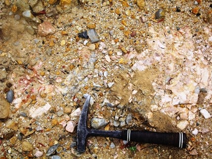
Secondly, an old quarry on the left of the highway about 200m past the Jenolan Caves turnoff. There is somewhere to park. The quarry is through the fence. This is best accessed if you are in the left lane and not so safe if you are coming down the River Lett Hill instead of going up. You can get clear of the traffic here and have a good look around. The place has become a dumping ground for all sorts of rocks and rubbish as well as a parking area for machinery, but there are some outcrops of quartz-orthoclase pegmatite on the upper side. I guess this is what was being quarried, probably for the extraction of the orthoclase which has lots of uses in industry. There are many small outcrops like this around Hartley. Few have been very productive. You can read about the industry and the origin of the pegmatite in the references given below.

Thirdly, along McKane’s Falls Road. This is a narrow, sealed road linking the Great Western Highway and the Jenolan Caves road. It turns off to the left towards the end of Hassan’s Walls at Old Bowenfels, several kilometres after the top of River Lett Hill, immediately after the new road constructions. Parking isn’t easy, but there is a reasonable spot on the right 3.1 km from the highway. From here you can see granite outcrops in the nearby paddocks and especially 
Outcrops near Mt Blaxland
towards Mt Blaxland on the left. Look out for aplite (microgranite) outcrops and areas with orthoclase phenocrysts weathering out of the granite and coarser pegmatites. From here you can continue on to the Jenolan Caves Road, crossing Coxs River just below Mt Blaxland which was the terminal point of the 1813 expedition led by Blaxland, Lawson and Wentworth.

Orthoclase from pegmatite
These early European explorers noted the outcrops of granite in the area, as did George Evans who followed up on their discoveries. William Cox’s road builders passed though here in 1814/15 and made good use of the rock for culverts and embankments.       Later visitors included some of more scientific bent and the area formed part of the first detailed geological map of the country west of the Blue Mountains (1875). Small quantities of gold and other metallic minerals were discovered, but the granite itself and the orthoclase in it's pegmatites has always been the resource of greatest value. Austen Quarry is extracting large quantities of these materials today and you will see it from a distance on the right as you return towards Hartley along the Jenolan Caves Road.

These references are all downloadable. Some of them have been relocated and finding them is something you will have to through Google or DIGS. See my blog entries on how to do this from Trove and DIGS.

The Geology of Sydney and the Blue Mountains (J Milne Curran 1899). Trove. Tick “Books” “online” and use the keywords “Curran” Geology” and “Sydney”. You will find several downloadable versions. Mineral Resources 26 Felspar in NSW (1917). DIGS Report Number: Mineral Resources 26.

Mineral Industry NSW Feldspar (1969) DIGS Report Number: Industry 15.

The Gap silver-lead-zinc mine, Hartley, near Lithgow (1970). DIGS Report Number: GS1970/293

Geological Map of Hartley, Bowenfels, Wallerawang, Rydal districts (1875). DIGS Report Number: Heritage Map H0252

Metallogenic Map Sydney (1980). DIGS Report Identification Number: R00027967

From the Sydney Metallogenic Map


Thursday, 5 December 2013

KATOOMBA FALLS – TO THE BOTTOM OF THE UPPER FALL

KATOOMBA FALLS – TO THE BOTTOM 

OF THE UPPER FALL

The Katoomba Falls area has always been popular with walkers and I guess it always will be. I’ve met many other walkers along the tracks and it’s great to see them enjoying the beauties of the place. Its proximity to the rides at Scenic World is partly the reason, of course, which provides opportunities for a number of round trips.

The track down to the Federal Pass level (where the Scenic Railway terminates) goes through two stages, coinciding with the descent through the two cliff-forming sandstone layers. Between the two is a prominent claystone bed which nearly always causes the top cliff line to be set back a little from the lower. This means that all the waterfalls from Katoomba to King’s Tableland at Wentworth Falls are split into upper and lower sections. This division is very obvious at Katoomba Falls.

The track into the valley descends on the right shortly after you leave Cliff Drive at the old Katoomba Falls Kiosk. It goes down into a rain forest world through a gap in the cliffs which may have once been the course of Kedumba Creek. A minor waterfall (also in two stages) called Witch’s (or Witches) Leap is soon seen on the right. The main Katoomba Falls may be seen from Rainforest Lookout soon after; just below this is the turnoff to “Under the Falls”, as it has often been called. It isn’t really under the falls, rather the spot is between the upper and lower falls.                                                                                                            
The brink of the lower Witch's Leap fall
Along this track you will cross the Witch’s Leap stream again, right at the brink of its second drop. Shortly after, you will arrive at the cascades between the two Katoomba Falls. You get an altogether different view of the falls here. Unfortunately its has proven to be a dangerous place for those who want to look at the bottom fall, which is why there is a solid safety rail well back from the edge. Not everyone takes notice of that, of course, and in summer people like to paddle around and take a shower. They are no doubt unaware of some of the grim events that happened here.

In July 1907 there was a cold snap which caused much of the waterfall to freeze over. This has happened a number of times, but on this occasion 
SMH July 9, 1907
the attraction of the frozen fall was too much for some visitors and two people died as a result of the slippery conditions. You may read about the tragedy in many newspapers of the day, but the Sydney Morning Herald of Tuesday 9 July 1907, page 7, is as good as any (See Trove). A similar freeze occurred in July 1922. A   few years ago we encountered a sizable icicle near Wollumai Lookout, between Katoomba Falls and Echo Point, so I guess this is a phenomenon that can still happen, even if it rarely does!

The 1907 event attracted a photographer who took pictures for and of tourists amongst the ice. A few of these survive and may be seen at the Blue Mountains Local Studies site here .

Several Wild Walks files are relevant to this walk. Katoomba Cascades here and Katoomba Falls Circuit here .

Finally, my video of the walk to “Under the Falls” may be seen here . My  Blue Mountains You Tube playlist may be found here. You will find videos of the Round Walk, Katoomba Cascades etc in the Blue Mountains playlist. In  other playlists - on gem hunting/mining, Glen Innes and New Zealand. Please comment and subscribe.

Icicle near Wollumai Lookout 2007

Friday, 8 November 2013

BARROW LOOKOUT BLACKHEATH BLUE MOUNTAINS NSW AUSTRALIA

BARROW LOOKOUT BLACKHEATH 

BLUE MOUNTAINS NSW AUSTRALIA


Barrow Lookout from Govett's Leap Lookout
Barrow Lookout is easily seen from Govett’s Leap Lookout, being just to the left of the waterfall and above it, on the cliff top track to Evans Lookout. It takes its name from the 19th century surveyor Isaac Le Pipre Barrow, who worked in the area.

Its location matches the place mentioned by Assistant Surveyor William Romaine Govett in his letter to Surveyor General Major Thomas Mitchell dated 1st July 1831.The Creek near ‘Blackheath’ after running about two miles and a half falls abruptly after the manner of the cascade at the ‘Weatherboard’ into one of the Gullies of the Grose River; at a point near this fall of water you have a grand view of two cascades, and that break of rock which forms such a particular (feature) in this Survey. Indeed I have not as yet seen a view which shews (sic) so well the character of the mountain feature …”. (Quoted from “Blackheath Today from Yesterday” p 131, edited by Peter C Rickwood and David J West, 2005).    
                                                                         
Govett's Leap from Barrow Lookout
No doubt Govett discovered the waterfall by following the creek we now know as Govett’s Leap Brook, rather than the ridge which ends with the present day Govett’s Leap Lookout. We need to take note at this point that the correct name for the waterfall is “Govett’s Leap” (not the Bridal Veil or Bridal Veil Falls), which name appears to have been given by Mitchell soon after Govett’s discovery. The monument at Govett’s Leap Lookout reads as follows: “This fall of water was named Govett’s Leap from the circumstance of William Romaine Govett Assistant Surveyor first having come upon the spot in June 1831”.

This concise statement of the facts is in stark contrast to the bizarre stories that abounded from the early 1870’s onwards, which had Govett as a bushranger, an escaped convict or convict overseer, a murderer and general vagabond. His “leap” was supposed to have been on horseback over a rocky gully (which he and his horse survived) or over the cliff (in which case they didn’t). Those responsible for promoting tourism in Blackheath could have easily contradicted these wild stories; however it seems that they used them to promote interest in the town and district. Even today poor Govett is seldom show the respect he deserves.

I don’t know when the name “Govett’s Leap” came into general use, but in the 1845 edition of Charles Darwin’sThe Voyage of the Beagle”, chapter 19 page 438 we read "Jan 18, 1836: Very early in the morning, I walked about three miles to see Govett's Leap: a view of a similar character with that near the Weatherboard, but perhaps even more stupendous.”
Not having seen Darwin’s original diary, I can’t say that he actually wrote this in 1836. Darwin corresponded with Major Thomas Mitchell and it is possible that he was given the name by him, inserting it into the text when he prepared his notes for publication. The name was certainly in common use when the railway opened to Mt Victoria on 1st May 1868. The first timetables suggest that the reason for trains stopping at Blackheath was so that visitors could go and see Govett’s Leap.
Readers might like to look up this reference in Trove: The World's News (Sydney, NSW: 1901 - 1955), Saturday 30 September 1922, page 20, 21.

Professor V. Gordon Childe
Now here is an intriguing story for readers of this blog to follow up. What happened to world renowned archaeologist, atheist and socialist Professor V. Gordon Childe at Barrow Lookout in 1957?

See the article by Dr Peter Rickwood in the “Blue Mountains History Journal”, Issue 3 October 2012 page 35. 


For my video on the walk from Govett's Leap Lookout to Barrow Lookout, click here