THE HARTLEY GRANITE,
BLUE MOUNTAINS NSW AUSTRALIA
 |
| From the 1875 Heritage Map |
At Mt Victoria
the Great Western Highway leaves the level of the Blue Mountains plateau and descends into the valley below via the Victoria Pass. From top to bottom you
can see the sedimentary layers of the Sydney
Basin, first the Narrabeen Group (Triassic) and then the Illawarra Coal
Measures and Shoalhaven Group (Permian). Once the valley floor has been
reached, cuttings reveal further Sydney Basin sediments before the road begins
to descend again towards Hartley.
 |
| Granite outcrops McKane's Falls road |
It is at this point that the first granite outcrops may be
seen and it is noteworthy that the elevation of the first granite is similar
all over the northern part of the Hartley Valley and adjoining areas. This is
because the Sydney Basin sediments here are resting on an old land surface
mostly made of granite which was itself formed as an intrusion (in the Lower
Carboniferous period) into older Devonian and Silurian sediments. See the blog
entry on the Unconformity at South
Bowenfels here for more information.
 |
| Normal granite, somewhat weathered |
 |
| Aplitic granite |
The difficulty you will experience in examining exposures of
the granite is essentially one of access. The land around is all private
property so you will be reduced to looking at road cuttings, for the most part.
Parking alongside the Highway or the Jenolan Caves Road at Hartley is not
recommended and in any case there is rarely anywhere to park near a cutting
where the best exposures are.
Here are three suggestions, based on approaching from the
direction of Sydney.
Firstly,
Hartley Village historic site. You will not be very popular with the National
Parks and Wildlife Service if you start hammering the natural outcrops here,
but at least you can see the typical granite tors on the hillside from a safe
place. What you will see is that the granite consists mainly of quartz and pink orthoclase felspar (I
prefer this spelling to feldspar) with lesser amounts of greenish plagioclase
felspar, biotite mica and miscellaneous other minerals.
This evening I looked up my first field notebook from August
1959 when I was 17 and just beginning to study geology. I had ridden my bike
from Lithgow and examined many outcrops along the way. Life was somewhat
simpler then! Here is my observation at Hartley.
“Near 2nd
church Hartley. Many granite boulders freshly blasted. Very big crystals of
pink feldspar.
 |
| Orthoclase phenocrysts weathering out |
One boulder covered with fern-like growths of a silver mineral
(hardness 4) and a brassy one (hardness 6).” Back to the present. Perhaps
that boulder or one like it is still there. What might the minerals have been?
The pink feldspar is orthoclase, in
the form of phenocrysts, which is typical of the Hartley Granite. You will find
it in every outcrop, though not always as larger crystals. The fern-like growths are dendrites, a form
which is typical of minerals which crystallise in confined spaces along joints.
They probably formed this way in the last stages of crystallisation of the
granite as the rock cracked and watery mineral solutions percolated through it.
The silver mineral could be
pyrrhotite (FeS), sphalerite (ZnS) or perhaps arsenopyrite (FeAsS). The brassy one could be pyrite (FeS₂).
Perhaps a reader will locate specimens and let us know what they think.
NOTE 20th December 2015.There is major road construction going on around Hartley. This has removed parking opportunities almost completely except at Hartley village. Lots of fresh granite has been exposed and then covered up with concrete. This may be good for roads, but it's certainly bad for the study of geology.
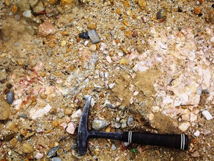 |
| Pegmatite outcrop, River Lett Hill |
Secondly, an old
quarry on the left of the highway about 200m past the Jenolan Caves turnoff. There is somewhere to park. The quarry is through the fence. This is best accessed if you are in the left lane and not so safe if you are coming down
the River Lett Hill instead of going up. You
can get clear of the traffic here and have a good look around. The place has
become a dumping ground for all sorts of rocks and rubbish as well as a parking area for machinery, but there are some
outcrops of quartz-orthoclase pegmatite
on the upper side. I guess this is what was being quarried, probably for the
extraction of the orthoclase which has lots of uses in industry. There are many
small outcrops like this around Hartley. Few have been very productive. You can
read about the industry and the origin of the pegmatite in the references given
below.
Thirdly, along
McKane’s Falls Road. This is a narrow, sealed road linking the Great Western
Highway and the Jenolan Caves road. It turns off to the left towards the end of
Hassan’s Walls at Old Bowenfels, several kilometres after the top of River Lett
Hill, immediately after the new road constructions. Parking isn’t easy, but there is a reasonable spot on the right 3.1 km
from the highway. From here you can see granite outcrops in the nearby paddocks
and especially
 |
| Outcrops near Mt Blaxland |
towards Mt Blaxland
on the left. Look out for aplite (microgranite) outcrops and areas with orthoclase
phenocrysts weathering out of the granite and coarser pegmatites. From here you
can continue on to the Jenolan Caves Road, crossing Coxs River just below Mt
Blaxland which was the terminal point of the 1813 expedition led by Blaxland, Lawson
and Wentworth.
 |
| Orthoclase from pegmatite |
These early European explorers noted the outcrops of granite
in the area, as did George Evans who followed up on their discoveries. William
Cox’s road builders passed though here in 1814/15 and made good use of the rock
for culverts and embankments. Later visitors included some of more scientific
bent and the area formed part of the first detailed geological map of the country
west of the Blue Mountains (1875). Small quantities of gold and other metallic
minerals were discovered, but the granite itself and the orthoclase in it's pegmatites
has always been the resource of greatest value. Austen Quarry is extracting large quantities of these materials
today and you will see it from a distance on the right as you return towards
Hartley along the Jenolan Caves Road.
These references
are all downloadable. Some of them have been relocated and finding them is something you will have to through Google or DIGS. See my blog entries on how to do this from Trove and
DIGS.
The Geology of Sydney and
the Blue Mountains (J Milne Curran 1899). Trove. Tick “Books” “online” and use the keywords “Curran” Geology”
and “Sydney”. You will find several downloadable versions. Mineral
Resources 26 Felspar in NSW (1917). DIGS Report Number: Mineral Resources 26.
Mineral Industry NSW
Feldspar (1969) DIGS Report Number: Industry
15.
The Gap silver-lead-zinc mine, Hartley, near
Lithgow (1970).
DIGS Report Number: GS1970/293
Geological Map of
Hartley, Bowenfels, Wallerawang, Rydal districts (1875). DIGS Report
Number: Heritage Map H0252
Metallogenic Map Sydney (1980). DIGS Report Identification Number: R00027967
https://johnsbluemountainsblog.blogspot.com/2013/12/links-to-all-blog-entries-and-relevant.html All Blue Mountains blogs and videos
All New England and other Geology blogs and videos
Limestone Caves of NSW
Song Studies. Bible studies based on hymns and songs
Shoalhaven District Geology
 |
| From the Sydney Metallogenic Map |


