Search This Blog

Showing posts with label picnic. Show all posts

Wednesday, 7 August 2019

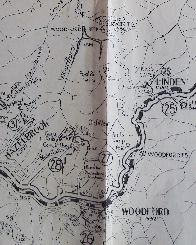
1938 Map (Part 26): WOODFORD - WILSON GLEN - SWIMMING POOL - WOODFORD

1938 Map (Part 26): WOODFORD - WILSON GLEN - SWIMMING POOL - WOODFORD

The places visited on this walk are part of a reserve set up as a memorial to Mrs Thomas M Wilson of Woodford in 1934. The story of the opening may be found here. It's from the "Katoomba Daily", 7th April 1934.
NOTE: The memorial park became inaccessible from the highway during road widening some years ago. The footbridge over the railway line is still there. Keith Painter has released a "Pocket Pal" booklet on this area

The monument at the entrance to the reserve

Tuesday, 4 June 2019

1938 MAP (PART 13): SPRINGWOOD TO MARTIN'S LOOKOUT

1938 MAP (PART 13): SPRINGWOOD TO MARTIN'S LOOKOUT

The walk as described in 1938 basically follows roads. While Martin's Lookout itself is well worth visiting, most people today would be more interested in the tracks which start there and use the route described as an access only.


Is the name "Echo Point" still used for this place? You can see it on the map just to the left of the words "Martin's Lookout".
Here is a video (drone footage) made at the lookout. here.
Lyre bird singing near Martin's Lookout. here. 
Most YouTube videos are about the track from Martin's Lookout to Lost World Lookout.


Wednesday, 3 December 2014

WENTWORTH FALLS LAKE BLUE MOUNTAINS NSW AUSTRALIA

WENTWORTH FALLS LAKE BLUE MOUNTAINS 
NSW AUSTRALIA

It’s not hard to see why a railway dam was constructed at the place we now know as Wentworth Falls. By that, I mean the township, not the waterfall. It is the only place between Glenbrook and Bell where the railway line actually crosses a watercourse.
The 1813 exploration led by Blaxland, Lawson and Wentworth successfully crossed the Blue Mountains because they stuck to the principle of following the ridgelines as they moved generally westward from the Nepean River at Emu Plains. When the expedition reached the cliff edge overlooking what we now know as the Jamison Valley at Wentworth Falls, they ran out of a ridgeline to follow. Turning north and keeping the watercourse we know as Jamison Creek on their left, they eventually reached its head and resumed following the main ridgeline again.
George Evans evidently crossed this creek when he retraced their route later that year, according to the plaque in the reserve beside the lake. However, William Cox and his roadmaking team stuck with Blaxland’s track in 1814/15 and headed the creek. He set up a depot near the creek which became known as the Weatherboard Hut, from his note on the map of the road to Bathurst. This appears to have been on the eastern side of the creek near the bridge over the railway line.
As soon as accurate maps began to be made by surveyors, it became clear that the road could be shortened by several miles by crossing the creek instead of going around its head. Just when this happened I don’t know, but you can be sure that Surveyor-General Thomas Mitchell would have insisted on this route when the road to Bathurst was being reconstructed in the 1830’s. Charles Darwin stayed at the Weatherboard Inn on the western side of the creek in 1836 and the inn had been there for several years by then. The railway builders of the mid 1860’s naturally followed the same ridgeline as the road and so the railway crossed Jamison Creek just where it does today. Steam engines need prodigious amounts of water and there are few places on the Blue Mountains Line where it can easily be obtained. Weatherboard (as the locality was then called) became the first railhead on 11th July, 1867 as the tracks pushed westward. So far as I can tell, the first railway dam was built at Lawson (then Blue Mountain) in that year. It wasn’t very adequate even if Blue Mountain was a good place for a watering stop. The supply at Lawson was augmented by larger dams in the valley to the north, the last of these being the ancestor of the Olympic Pool in Wilson Park.
Jamison Creek Below the Dam Wall
The line was soon extended to Mt Victoria, this extension being opened on 1st May 1868. The chosen spot for watering engines in the upper mountains was Blackheath, originally intended as the temporary terminus. Water was pumped from dams across Pope’s Glen Creek and, as in Lawson, their descendants became swimming holes. The upper one gave rise to today’s beautiful pool in Blackheath’s Memorial Park; the lower dam becoming the duck pond. The water supply from this source eventually became inadequate and a replacement dam was built on Govett’s Leap Brook.
Further dams were needed as the next section of line was constructed, the line descending via the Great Zig Zag into Lithgow’s Valley to the new railhead at Bowenfels. This section was opened on 18th October 1869. I believe these dams were at Clarence and Zig Zag.
Another dam on Dargan’s Creek (Newnes’ Junction) was needed to service engines on the Newnes branch line some time later.
Eventually it was decided that only the creek at Wentworth Falls could supply the volume of water for the rapidly expanding rail network. The large dam, backing up into what we know as Wentworth Falls Lake, was completed in the early years of the twentieth century and supplied water by a pipeline to watering points as far down the mountains as Valley Heights. This sufficed until electrification and dieselisation made steam engines practically redundant on the Blue Mountains by 1960.
The development of the dam as a recreation area happened over many years. It was too good a resource to go to waste and it has become the most diverse and extensive recreation area in the Blue Mountains City. Now you can have a picnic (with barbecue), enjoy the two children’s play areas, fish from the shore or the dam wall and appreciate the many water birds as you walk around the shores of the lake. Swimming isn’t recommended, however, as it is difficult to guarantee water quality when there are residential areas in the catchment. One improvement is a new, centrally located toilet block. 
Further Information:
My Video: here     "Cloudscape" Blog: here

Wednesday, 9 April 2014

HINKLER PARK, KATOOMBA BLUE MOUNTAINS NSW AUSTRALIA

HINKLER PARK, KATOOMBA BLUE MOUNTAINS 
NSW AUSTRALIA

Hinkler Memorial Park is in Warialda St Katoomba, between Katoomba St and Lurline St. What distinguishes it from most other parks in the Blue Mountains is that it offers both a shelter shed and toilets as well as a children’s play area and a pleasant environment. It may not be very large but it is certainly very popular. You will probably only have it to yourself on a wet day.
Apparently the place was known as Lurline St Park before 1933, though I have been unable to find anything to suggest that there were any facilities there at all. All that was to change.
Herbert John Louis Hinkler (always known simply as Bert Hinkler) was born in Bundaberg, Queensland, in 1892. His interest in flying went back to his childhood and it was no surprise that he served, first in the Royal Naval Air Service and then in the RAF during the First World War, concluding the war as a pilot in Italy in 1918.
He was catapulted to fame in 1928 when he became the first person to fly solo from England to Australia, taking just under 15 ½ days. An unassuming man, Bert became an advocate for the aeroplane as he flew many new routes, solo whenever possible. He was killed in Italy in January 1933 when his plane crashed as he sought to break the new solo flight record to Australia of 8 days and 20 hours. He was greatly admired and Australians everywhere mourned his passing.                     
Hinkler Park 1938
The Katoomba Municipal Council determined to honour his memory by creating the park we know today. As you can see from the photographs and my video (here) they did a great job. See the Sydney Morning Herald article about the opening here.
Commemorative plaque on shelter
You might also enjoy hearing the man himself speak on a recording here. 
There is one small mystery you might like to help solve. At the top of the plaque commemorating the opening, which is on the side of the shelter shed, there is an engraving of what I assume was one of Hinkler’s planes. It is not the one he flew on the record breaking flight in 1928. Is it perhaps the one in which he was killed in 1933?
Note May 2024. It is.

Friday, 28 March 2014

SUBLIME POINT, LEURA NSW AUSTRALIA

Rear view of the Three Sisters
While the Sublime Point Lookout doesn’t attract the crowds of many other Blue Mountains lookouts, it still has much to offer.
Sublime Point seems to have first come to public notice (at least, under the present name) around 1890-95. Mr WH Copeland, a Katoomba businessman, found a way into the Jamison Valley from the Point (Copeland Pass). This way into the valley is used today by rock climbers, who have developed many routes on the imposing cliffs in the area.

The path and picnic facilities probably date from the 1950’s and resemble those at Cahill’s Lookout, which dates from the same period.   One unexpected feature is the tap at the end of the path, several hundred metres from the parking  
Distant view of the Katoomba skyline
area, which also has one. The provision of a shelter shed and picnic tables near the lookout is very welcome, though it is quite a way to carry your picnic gear from the car.
You will need to follow your road maps carefully to find the way out to Sublime Point. Basically, the route is the same as for Fairmont Resort and the Leura Golf Course, where Sublime Point Road actually commences.
The area has seen many cases of lost bushwalkers and a number of fatal climbing accidents. It came to prominence in September 2013 when the body of a missing guest from Fairmont was discovered wedged in a tree part way down the cliff on the western side of Sublime Point.
An article in the Sydney Morning Herald about the discovery of the body may be found here.
Gary Tweddle disappeared from Fairmont in the early hours of July 16th 2013. There is a memorial plaque to Gary along a track which branches off to the right about half way between the car park and the picnic area. This track leads around the cliff top to Golf Links Lookout, if you succeed in following it through the scrub and across people’s backyards.
My video on Sublime Point will be found here. 

From a 1905 Katoomba guide book.


Distant view of Mt Gibraltar, Bowral

Monday, 10 March 2014

CAHILL’S LOOKOUT, KATOOMBA BLUE MOUNTAINS NSW AUSTRALIA

CAHILL’S LOOKOUT, KATOOMBA 
BLUE MOUNTAINS NSW AUSTRALIA

John Joseph Cahill was the Premier of New South Wales from 1952 to 1959. It was in his term of office that such well known Sydney landmarks as the Cahill Expressway at Circular Quay and the Sydney Opera House were planned. The Blue Mountains City Council named this magnificent lookout in his honour.
Unlike most of the Katoomba lookouts such as those at Echo Point and Scenic World, which overlook the Jamison Valley, this one overlooks the Megalong Valley. The two valleys are separated by the Narrow Neck, a remnant of the sandstone plateau which projects southwards for many kilometres.
The streams which formed the Megalong Valley have eroded through the Sydney Basin sediments into the underlying granite and other older rocks. Much of the western side of the valley has been cleared for sheep and cattle grazing.
The Boar's Head
Two well known landmarks visible from Cahill’s Lookout are the Boar’s Head Rock (easily seen on your left towards Narrow Neck) and the Six Foot Track to Jenolan Caves. The track may be seen snaking through the forest below the lookout (the bottom one, that is) after the descent through Nellie’s Glen, which is on your right.
There is a picnic area alongside the parking area at the beginning of the concrete path and steps leading down to the lookout. Unfortunately there are no toilet facilities. However there is a tap near the path and an overgrown drinking fountain (bubbler to we older Australians) at the lookout. I can’t say whether they work or not, but the ones at Sublime Point lookout, which date from the same period, certainly do.
This spot is one of the best places in the Blue Mountains to enjoy a sunset, because of its westerly aspect. It is reached from the loop section of Cliff Drive (Blue Mountains Drive), shortly after passing the golf course, proceeding from the direction of Scenic World.
My video on Cahill’s Lookout may be found here. Another video, taken on a very windy day, is here. 
The picnic area and access paths were reconstructed after the 2014 bushfire and now attract many more visitors. See my video "Cahill's Lookout Reopened" here.

Nellie's Glen from Cahill's Lookout