Search This Blog

Showing posts with label Wentworth Falls. Show all posts

Wednesday, 17 April 2019

1938 MAP AND WALKS INFORMATION (Part 1)

1938 MAP AND WALKS INFORMATION (Part 1)


1938 MAP AND WALKING TOURS ON THE BLUE MOUNTAINS BETWEEN BLAXLAND AND WENTWORTH FALLS. This publication by the NSW Railways Department has maps and information on numerous walks. This page is simply the section which introduces the map. You will need to use it when you want explanations about symbols etc. This folder belonged to Grandma Hayward.

You will find a lot of interesting things that modern books will not mention (and vice versa, of course).

Wentworth Falls April 1957
If anyone has a copy of the related folder dealing with areas higher up the Blue Mountains than Wentworth Falls would they please let me know.


Monday, 15 April 2019

CHARLES DARWIN CROSSES THE BLUE MOUNTAINS IN 1836


Painting by G Richmond
CHARLES DARWIN CROSSES THE BLUE MOUNTAINS IN 1836

Today when we hear or read about “The Voyage of the Beagle” we immediately think of the young Charles Darwin gathering material for his research into the theory of evolution. While it’s true that he made use of a lot of the information and specimens he collected on that voyage, the story of the Beagle, or at least Darwin’s part in it, is that of a young naturalist being given the opportunity to explore a world full of undiscovered and unexplained wonders.

The “Beagle” was on a world trip of scientific exploration (1831-36). In January 1836 the ship arrived in Sydney and Darwin (along with several others) made his only inland journey in Australia, across the Blue Mountains to Bathurst. Read his account in the pages below.


Reproduction of frontispiece by RT Pritchett from the first Murray illustrated edition, 1890. “HMS Beagle in the Straits of Magellan at Monte Sarmiento".  

The Voyage of the Beagle is the title most commonly given to the book written by Charles Darwin and published in 1839 as his Journal and Remarks, bringing him considerable fame and respect. This was the third volume of “The Narrative of the Voyages of H.M. Ships Adventure and Beagle”, the other volumes of which were written or edited by the commanders of the ships. Journal and Remarks covers Darwin's part in the second survey expedition of the ship HMS Beagle. Due to the popularity of Darwin's account, the publisher reissued it later in 1839 as Darwin's Journal of Researches, and the revised second edition published in 1845 used this title. A republication of the book in 1905 introduced the title The Voyage of the "Beagle", by which it is now best known.

The pages below are from an 1845 printing, located by searching “Trove”.


One final word. The point where the Mudgee track left the Bathurst road is quite close to where I live. Mudgee St is still there. The map dates from 1842.

Thursday, 29 March 2018

WILSON PARK WENTWORTH FALLS


WILSON PARK AT WENTWORTH FALLS
This blog is intended to be read in association with my video on Wilson Park, which you will find here: https://youtu.be/hs7ThVqg3cY.
The story below appeared in the Sydney Morning Herald, Saturday 11th October 1930 on page 14.
Many changes over the years make finding the exact spot difficult (perhaps impossible). It must have been next to the Great Western Highway, between Jamison Creek and the Bowling Club.

"WENTWORTH FALLS, Friday.
The recently-named Wilson Park, Wentworth Falls, adjoins Jamieson Creek. It has been a public reserve for very many years, but was not gazetted as such for a considerable time. When the road over the Blue Mountains was constructed in Governor Macquarie’s time this site was used as a depot by the gangs at work on the road On previous occasions various relics of the past have been dug up here such as handcuffs and leg-irons.
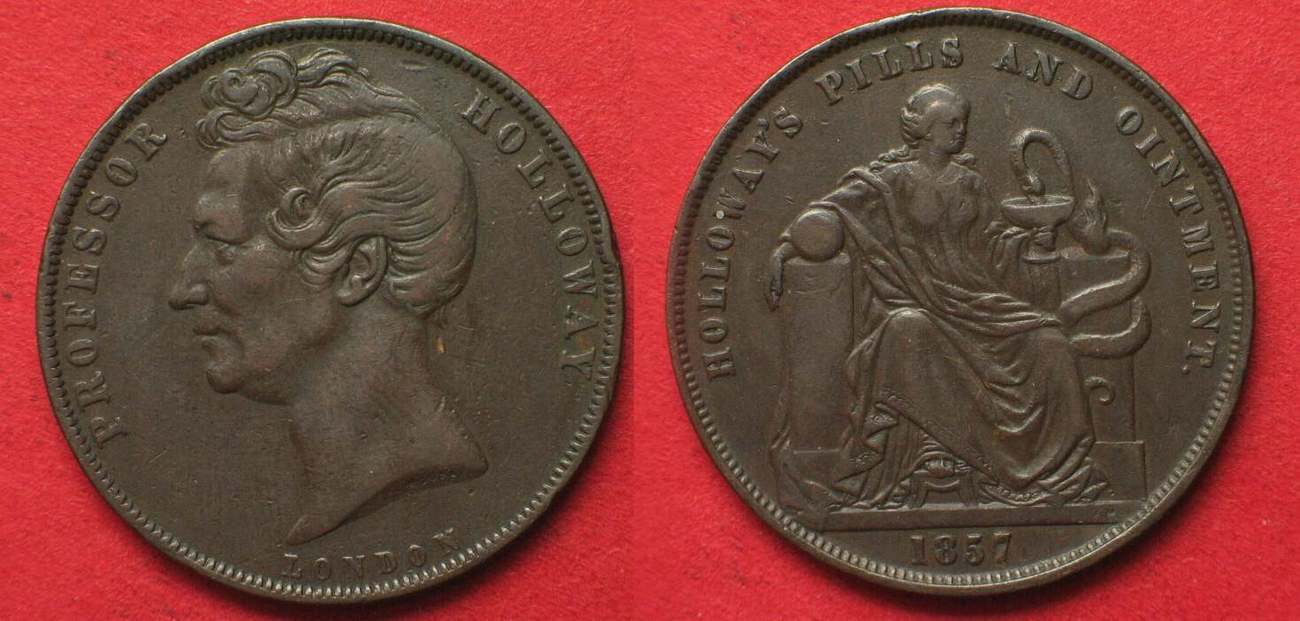
The men now carrying out improvements to the park have found several relics, including a warder's badge numbered 23, an old flint pistol, several percussion caps, and a military heel screw spur. They have also found a number of copper coins – pennies, half-pennies and farthings. The oldest coin was a big penny with a 1797 date. In addition they found an advertisement disc resembling a coin or medal bearing the slogan “Professor Holloway”, of ointment fame located in Sydney. Two pairs of scissors, a tablespoon a large padlock and a Jew's harp have been unearthed. A military button with an embossed crown was dug up and several bullets that had been cast in a rough mould."

NOTES. The 1797 penny referred to is the celebrated cartwheel penny, which must have remained in circulation until the 1860's. I have found one near our home in South Bowenfels, 40 or 50 km closer to Bathurst.
No Australian farthings were issued but UK specimens are not uncommon finds.
The Professor Holloway "disc" is what is called a "Token" in Australia. They circulated as pennies or halfpennies in times of coin shortages, during the gold rush years before being banned during the 1870's.
No doubt there would have been many black glass "ale" bottles found on the site as well.
Image result for professor holloway 1857 penny token  Image result for cartwheel penny australia


Sunday, 4 January 2015

WATER NYMPH’S DELL WENTWORTH FALLS

WATER NYMPH’S DELL WENTWORTH FALLS


If you’re travelling by train, then this is a pleasant round walk you can do from Wentworth Falls station. It’s on the opposite side of the line from the shops and actually closer than the better known walks on the Jamison Valley side. If travelling by car, then turn at the traffic lights, go past the shops and over the railway line. Take the first to the right (Railway Parade) and park in the commuter car park. My video on the walk (here) describes the route from the railway bridge.

Mountaineer Tourist Guide 1927
You can, of course, commence at the other end of the track, but it’s more difficult to describe how to get there. Incidentally, if it’s a clear day, you can see the high rise buildings in central Sydney from the bridge.

Railway Tourist Guide 1938
Just who gave the name “Water Nymph’s Dell” to this attractive rainforest gully and when, I don’t know. The earliest reference I’ve come across (using Trove) is from the Nepean Times (Penrith) for Saturday 25th August 1888, page 4. You can download the whole story here if you wish. The gist of it is that a committee of local residents is requesting that Water Nymph’s Dell be set apart as a reserve “as it is one of the most beautiful dells on the mountains”. This did indeed happen and the area remains a reserve to this day, though not part of the Blue Mountains National Park.
Track conditions vary from excellent to poor. There are some fine examples of nineteenth century stone steps, especially on the ascent up the other side of the valley. There is a solitary picnic table under an overhang which I’m sure was there when I visited the place as a boy 60 years ago. The central feature of the dell is a small waterfall and associated pool, which, while not exactly suitable for swimming, looks like it ought to be able to entertain small children (under close supervision, of course).
We are lucky to have this place in as good condition as it is. Over the years it has suffered from neglect, threats from loggers, invasion by weeds and leaky sewer pipes. The Water Nymph's Dell Bushcare Group has done a fantastic job of rehabilitation and protection. 

As I was gathering this information, I came across many accounts of tourist visits to the area, but none more interesting than one in the Clarence and Richmond Examiner (Grafton) for 19th November 1901, page 2. 
How I would have loved to have known the mountains as they were then! Somehow, the growth of population and the management of the reserves by local and state government authorities (excellent though it is) can never be the same as it was in those far off days when everything was fresh and exciting and the local people through their Reserve Trusts were directly involved in developing, maintaining and promoting the sights in their immediate area. Read this article in the Examiner in full here. Yes, there are ferruginous stalactites there today, much like the ones at Fairy Falls, Lawson.


Wednesday, 3 December 2014

WENTWORTH FALLS LAKE BLUE MOUNTAINS NSW AUSTRALIA

WENTWORTH FALLS LAKE BLUE MOUNTAINS 
NSW AUSTRALIA

It’s not hard to see why a railway dam was constructed at the place we now know as Wentworth Falls. By that, I mean the township, not the waterfall. It is the only place between Glenbrook and Bell where the railway line actually crosses a watercourse.
The 1813 exploration led by Blaxland, Lawson and Wentworth successfully crossed the Blue Mountains because they stuck to the principle of following the ridgelines as they moved generally westward from the Nepean River at Emu Plains. When the expedition reached the cliff edge overlooking what we now know as the Jamison Valley at Wentworth Falls, they ran out of a ridgeline to follow. Turning north and keeping the watercourse we know as Jamison Creek on their left, they eventually reached its head and resumed following the main ridgeline again.
George Evans evidently crossed this creek when he retraced their route later that year, according to the plaque in the reserve beside the lake. However, William Cox and his roadmaking team stuck with Blaxland’s track in 1814/15 and headed the creek. He set up a depot near the creek which became known as the Weatherboard Hut, from his note on the map of the road to Bathurst. This appears to have been on the eastern side of the creek near the bridge over the railway line.
As soon as accurate maps began to be made by surveyors, it became clear that the road could be shortened by several miles by crossing the creek instead of going around its head. Just when this happened I don’t know, but you can be sure that Surveyor-General Thomas Mitchell would have insisted on this route when the road to Bathurst was being reconstructed in the 1830’s. Charles Darwin stayed at the Weatherboard Inn on the western side of the creek in 1836 and the inn had been there for several years by then. The railway builders of the mid 1860’s naturally followed the same ridgeline as the road and so the railway crossed Jamison Creek just where it does today. Steam engines need prodigious amounts of water and there are few places on the Blue Mountains Line where it can easily be obtained. Weatherboard (as the locality was then called) became the first railhead on 11th July, 1867 as the tracks pushed westward. So far as I can tell, the first railway dam was built at Lawson (then Blue Mountain) in that year. It wasn’t very adequate even if Blue Mountain was a good place for a watering stop. The supply at Lawson was augmented by larger dams in the valley to the north, the last of these being the ancestor of the Olympic Pool in Wilson Park.
Jamison Creek Below the Dam Wall
The line was soon extended to Mt Victoria, this extension being opened on 1st May 1868. The chosen spot for watering engines in the upper mountains was Blackheath, originally intended as the temporary terminus. Water was pumped from dams across Pope’s Glen Creek and, as in Lawson, their descendants became swimming holes. The upper one gave rise to today’s beautiful pool in Blackheath’s Memorial Park; the lower dam becoming the duck pond. The water supply from this source eventually became inadequate and a replacement dam was built on Govett’s Leap Brook.
Further dams were needed as the next section of line was constructed, the line descending via the Great Zig Zag into Lithgow’s Valley to the new railhead at Bowenfels. This section was opened on 18th October 1869. I believe these dams were at Clarence and Zig Zag.
Another dam on Dargan’s Creek (Newnes’ Junction) was needed to service engines on the Newnes branch line some time later.
Eventually it was decided that only the creek at Wentworth Falls could supply the volume of water for the rapidly expanding rail network. The large dam, backing up into what we know as Wentworth Falls Lake, was completed in the early years of the twentieth century and supplied water by a pipeline to watering points as far down the mountains as Valley Heights. This sufficed until electrification and dieselisation made steam engines practically redundant on the Blue Mountains by 1960.
The development of the dam as a recreation area happened over many years. It was too good a resource to go to waste and it has become the most diverse and extensive recreation area in the Blue Mountains City. Now you can have a picnic (with barbecue), enjoy the two children’s play areas, fish from the shore or the dam wall and appreciate the many water birds as you walk around the shores of the lake. Swimming isn’t recommended, however, as it is difficult to guarantee water quality when there are residential areas in the catchment. One improvement is a new, centrally located toilet block. 
Further Information:
My Video: here     "Cloudscape" Blog: here

Wednesday, 24 September 2014

THE NATIONAL PASS WENTWORTH FALLS NSW AUSTRALIA

THE NATIONAL PASS WENTWORTH FALLS 
NSW AUSTRALIA

The Cliff Ledge section of the track
So much has been written about this famous walk, and so many photographs taken, that it almost seems unnecessary to add to them. However, this is my own experience of the Blue Mountains that I am writing about, so I make no further apologies.
My earliest memories of the National Pass go back to a time just after World War 11, possibly before my father began working at Wunderlich’s brick and tile factory in Sydney, which would place it in 1945. The only thing I can actually recall is being carried across the shaky and dangerous bridges at the bottom of the Falls. Goodness knows when the last repairs had been made to them.
Much more recently, my own children did the walk 
Roland, Yvonne and Lyndall Paix 1978
at a tender age in 1978. On my recent walk, I encountered numerous seniors, so if you’re getting on in years don’t let your age be the deciding factor. True, there are lots of steps to get down into the valley and return, but just take these slowly and all should be well.
The round walk easily divides into 5 sections and each one has an interesting history of its own.
The best place to find car parking is at the Wentworth Falls Picnic Area, and since your walk is going to take around 4 hours it makes sense to arrive early to be sure of finding a spot. Carry your lunch with you and enjoy it along the track. Make sure you have plenty of water as well, 
Empress Falls Valley of the Waters
since drinking from the many streams you will encounter is not  recommended. The alternative car park at the Conservation Hut is often filled up by patrons enjoying the fine food on offer there.
Sylvia Falls Valley of the Waters


I recommend that you take the Short Cut Track from the bottom car park, which is a pleasant walk of 15-20 minutes leading to the Conservation Hut. Historically, there has been a track between these 2 areas for over 100 years, because it made round trips possible.  This is Section 1. 
Section 2 is the magnificent descent into the Valley of the Waters. If you love the sound and sight of falling water, this place is for you. Take the steps and ladders slowly and savour every moment in this magical place. People like you have been coming here for 120 years and it isn’t difficult to see why.
Section 3 (the first part of the actual National Pass section) begins at the final creek crossing just above Lodore Falls and takes you onto the extraordinary cliff ledge leading around to the bottom of the first drop of Wentworth Falls. Before 1906, it was possible to go further down into the valley and follow up Jamison Creek to the bottom of the second fall, but it was only the completion of the ledge track that allowed easy access to bottom of the first 
fall. All along this section (and up the Grand Stairway) the National Parks and Wild Life Service has installed commemorative plaques and information panels telling of the restoration of the track and the environment through which it passes. These are a valuable addition to your walking experience.
The area immediately below Wentworth Falls is like a magnet which draws lots of people to it, many of whom descend the stairs and return the same way. If you want to find this place peaceful and quiet, then avoid school holidays and weekends.
Materials used during the restoration of the track
Section 4, the stone stairway up the cliff face,  is surely the highlight of the National Pass adventure. Completed in 1908, it made the round trip as we know it possible. You can discover lots about this magnificent feat of engineering in many places, but here are two of the best. The first I will simply call “a very special presentation”, which you may access here. The second is the NPWS site which is also excellent.
Den Fenella Falls
Section 5 consists of the track from the creek crossing to the Wentworth Falls picnic area. This route, more or less, has been in use for 150 years.
My own video of this walk may be found here. Unfortunately, my camera battery failed just after I  had passed behind Den Fenella Falls, so this part of the trip is not included. One day I’ll do the trip again (and again, if my body permits me) and there will be a new video to record the event.
NOTE: THE PASS IS CLOSED DUE TO ROCKFALLS AS AT AUGUST 2019 AND HAS BEEN FOR OVER A YEAR.


Vera and John Paix on the Grand Stairway June 1958