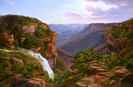
Search This Blog

Showing posts with label Falls. Show all posts

Friday, 20 September 2019

1938 MAP (PART 35): HAZELBROOK - SWIMMING POOL - CATARACT FALLS - FEDERAL FALLS - JUNCTION FALLS - ADELINA FALLS - LAWSON

1938 MAP (PART 35): HAZELBROOK -  SWIMMING POOL - CATARACT FALLS - FEDERAL FALLS - JUNCTION FALLS - ADELINA FALLS -  LAWSON

This walk takes in a lot of lookouts and waterfalls as it makes its way from Hazelbrook to Lawson. A road follows the route today, so a current map is essential.
The Baths (near the beginning of the walk) were at one time a well developed site - basically a wreck today (if you can find them).
https://trove.nla.gov.au/newspaper/article/194479621# Here is an extract from the article.
"In answer to the request of the Hazelbrook Urban Committee for a report regarding the possible enlargement of the Hazelbrook Pool, the Shire Engineer reported in a very comprehensive manner."


South Lawson Waterfall Walk: https://www.youtube.com/watch?v=ZtIeti5FNgE


Wednesday, 4 September 2019

1938 MAP (PART 33): HAZELBROOK - VICTOR FALLS - LAKE AVENUE - HAZELBROOK

1938 MAP (PART 33): HAZELBROOK - VICTOR FALLS - LAKE AVENUE - HAZELBROOK

This walk follows some parts of Route 32, but does not go down the gully to Terrace Falls. Instead it only goes to Victor Falls before returning to Hazelbrook.

Victor Falls. Thanks to an unknown artist.


Thursday, 29 August 2019

1938 MAP (PART 32): HAZELBROOK - VICTOR FALLS - TERRACE FALLS - THE LAKE - LAKE AVENUE - HAZELBROOK

1938 MAP (PART 32): HAZELBROOK - VICTOR FALLS - TERRACE FALLS - THE LAKE - LAKE AVENUE - HAZELBROOK

The Terrace Falls area at Hazelbrook is one of the most interesting in the Blue Mountains. I can recommend Keith Painter's "Pocket Pal" booklet titled "Terrace Falls" for modern descriptions of walks in this area. See the website www.mountainmistbooks.com for more information.
There are many online photographs, walk descriptions and videos you can check out. Here are a few. 
Terrace Falls Walk Hazelbrook (David Noble): http://www.david-noble.net/blog/?p=2861


Thursday, 22 August 2019

1938 MAP (PART 31): HAZELBROOK - BURGESS FALLS, THE AMPHITHEATRE, HORSESHOE FALLS, LYRE BIRD GLEN - HAZELBROOK
This walk is essentially the previous one (31) in reverse, though the wording  is somewhat different. Whatever comments, videos etc are printed there apply here.


Tuesday, 13 August 2019

1938 Map Part 28: WOODFORD - MABEL FALLS AND CONVICT POOL - EDITH FALLS AND FAIRY FALLS - WOODFORD (PART 27 REVERSED)
This walk is the reverse of the previous one (Part 27) and is included here for the sake of completion.


Song Studies. Bible studies based on hymns and songs
Shoalhaven District Geology.                 

Saturday, 10 August 2019

1938 Map (Part 27) WOODFORD - EDITH FALLS - FAIRY FALLS - MABEL FALLS - CONVICT POOL - WOODFORD

1938 Map (Part 27) WOODFORD - EDITH FALLS - FAIRY FALLS - MABEL FALLS - CONVICT POOL - WOODFORD

The list of places in the title looks inviting. I haven't been to any of them so I suggest you consult a current guide book or search the Internet (or both).


Song Studies. Bible studies based on hymns and songs
Shoalhaven District Geology.                        

Saturday, 23 September 2017

VANIMAN’S LOOKOUT KATOOMBA

VANIMAN’S LOOKOUT KATOOMBA

The name “Melvin Vaniman” is hardly well known today, yet in 1903 the opposite was true.
I’ve been familiar with Vaniman’s Lookout at Katoomba for the past 60 years but until we came to live at Lithgow I assumed that Vaniman was a local dignitary or politician of some sort. The first inkling that this was not the case came when I read that he was an American photographer who visited the Blue Mountains in the early years of the 20th century.
Melvin Vaniman and Kiddo the Cat
He certainly was that, but perhaps “American adventurer” would be a better description. Here are a few lines from Wikipedia (here) used to describe him. “Chester Melvin Vaniman (1866 – 1912) was an American photographer, adventurer and businessman who specialized in panoramic images taken from height and was nicknamed the "Acrobatic Photographer." Other descriptions refer to him as a competent opera singer and a pioneer aviator.
Newspaper article
 about the Akron
It was in this latter role that his life ended in a fiery accident in which the hydrogen-filled airship “Akron” caught fire and crashed on July 2nd 1912. It had been intended to use the craft in an attempt to be the first to fly across the Atlantic Ocean.
Vaniman’s association with the Blue Mountains occurred in November 1903. He was engaged in taking large photographs of interesting places around the world. When I say “large”, imagine a glass photographic plate “48 by 16 inches and embracing a panorama of over 190 degrees” (Mountaineer (Katoomba, NSW : 1894 - 1908), Friday 27 November 1903, page 3) according to Trove (reference here).
The article goes on to say “Some idea of the vastness of the panorama can be obtained when we explain that a picture was obtained of Katoomba Falls and the surroundings, which takes in the top Lookout, the Falls, the Three Sisters, the Broken Wall, Mount Solitary and round to the Orphan Rock.” I believe that this particular photograph was taken from what we now know as “Vaniman’s Lookout”, which had acquired this name by 1905. I have yet to find any other mention of such a photograph.
The photograph which the Mountaineer article was mostly interested in is the one shown below, taken from atop a pole 80 feet high near Gearin’s Hotel, which can be seen in the right foreground.
I read somewhere that a copy of this photograph had been purchased by the Katoomba Council and was to be displayed in a public building in the town. Where is it now?
Taken around 1940 by Wallace Green
The pictures illustrating this blog show the typical development of a mountain lookout. (Thank you to the photographers and the current owners of these). At first, the railings were made of locally cut poles. Later these were replaced by steel posts and chicken wire. More recently came the sturdy structures seen in the present day throughout the area. Presumably in the near future there will be more of the fencing currently seen around Katoomba Cascades – effective, but not as photogenic as the earlier fences were. Missing today is the bench on which to sit and marvel at the scenery.

Photograph taken in 1905

Photo by John Paix 2014
See also my YouTube videos and Blogs:
The Round Walk Katoomba Falls Blog: here
The Round Walk: here

Thursday, 25 June 2015

KATOOMBA FALLS WALKING TRACKS BLUE MOUNTAINS NSW AUSTRALIA

KATOOMBA FALLS WALKING TRACKS BLUE MOUNTAINS NSW AUSTRALIA

The Katoomba Falls area was one of the first in the Blue Mountains opened up for tourists to enjoy. Local residents probably made the first rough tracks from the vicinity of today’s railway station down to the number one attraction – Katoomba Falls. The opening of the nearby coal mine around the same time made access easier to this area and the basic network of tracks we know today was in existence well before 1900.

Quite a lot of my videos and blogs have been about this area. In fact, we seem to have lunch or afternoon tea in the reserve nearly every week. Here is a list of these – with links – which will help you to explore the area from the comfort of your own home (or from along the track, if you are so inclined).
The illustrations come various old guide books I’ve downloaded through Trove.
Videos
Katoomba Holiday Part 2 21st May 2015 
Katoomba Holiday Part 1 8th May 2015 
AShort Round Walk at Katoomba Falls 21st November 2014   
Katoomba Falls to Scenic World 12th September 2014 
Katoomba Cascades to Echo Point 25th January 2014 
Furber Steps Katoomba Falls 23rd January 2014 
Blog Entries
The Round Walk Katoomba Falls 15th September 2013 
Katoomba Falls Reserve 26th August 2013 
The Orphan Rock 21st August 2013 
Please let me know via the comments section below or on individual blogs or videos if you find something that should be corrected (or added).


Sunday, 20 October 2013

WENTWORTH FALLS, BLUE MOUNTAINS NEW SOUTH WALES AUSTRALIA

WENTWORTH FALLS

BLUE MOUNTAINS NEW SOUTH WALES AUSTRALIA


The Falls from Fletcher's Lookout November 2005
The waterfall we now know as Wentworth Falls may well have been sighted during the first European crossing of the Blue Mountains in 1813. The expedition had been following the ridge dividing the streams flowing north into the Grose River and those flowing south into the Nepean River (Glenbrook Creek, Bedford Creek etc). Their route brought them out onto the edge of King’s Tableland, south of the present day township of Wentworth Falls, forcing them to deviate to the north to get around the cliffs of what we now call the Jamison Valley.

Whether George Evans or William Cox saw the falls (1813-1815) I have been unable to establish, but as Governor Lachlan Macquarie’s party was taken out in 1815 to see the falls and the valley we must assume that they were already known by then. Macquarie named the falls “Campbell’s Cataract”, after his secretary John Thomas Campbell, who was actually his wife Elizabeth’s brother. The name “Jamison Valley” (various spellings) dates from this time, also “Prince Regent’s Glen” and “King’s Tableland”.           
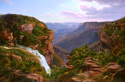
The Weatherboard Creek Falls. Eugene Von Guerard 1862
Despite Governor Brisbane renaming the falls to “Bougainville Falls” in 1825 to honour the leader of a French scientific expedition at that time, the public began to use the name “Weatherboard Falls”, after Cox’s 1814 weatherboard store hut built on Jamison Creek, upstream of the falls, and later the Weatherboard Inn, built 1826-29. Most travellers who could afford to stay at an inn stayed here, and many walked out to see the falls and the valley.

Charles Darwin recorded his visit in 1836 in his account of the voyage of the Beagle; he appears to have stayed at the Weatherboard Inn on his outward journey to Wallerawang and Bathurst and again on his return, walking to the falls on both occasions.
The Weatherboard Falls, Blue Mountains.
 JH Carse 1876
The name “Weatherboard Falls” began to be replaced by “Wentworth Falls” following the renaming of the railway station in 1879. The falls became the centrepiece of the reserve established there, formerly administered by a local trust, then by the Blue Mountains City Council and now by the National Parks and Wildlife Service. More will be said about this in a later blog entry.

Here are some useful sites you can visit. Firstly, from the Wild Walks site, covering the track to the top of the falls via Fletcher’s Lookout, then the Undercliff Track and finally the Princes Rock track here, here and here .

Wentworth Falls February 2013
The photograph of Wentworth Falls in extreme flood in February 2013 comes from this article here.

Here are two interesting videos. The first shows the falls in flood here and the second in strong wind here.  

Finally, my own You Tube site, which includes a video on a walk to the falls via Fletcher’s Lookout, returning via the Undercliff and Princes Rock tracks here . 

The two paintings illustrated are on display in the National Gallery of Victoria, Melbourne.


The Weeping Rock, Wentworth Falls. June 1958

Friday, 4 October 2013

LEURA CASCADES PICNIC AREAS BLUE MOUNTAINS NEW SOUTH WALES AUSTRALIA

LEURA CASCADES PICNIC AREAS BLUE MOUNTAINS NEW SOUTH WALES AUSTRALIA

This has been a favourite place for picnics since the Katoomba Baths were opened here in 1913. Before then, many people came down the tracks from both Katoomba and Leura stations to visit the Leura Cascades and Leura Falls, especially after the opening of the Federal Pass track earlier in the century. The completion of the baths, with associated change rooms, toilets and picnic areas brought many more visitors. The area remains popular today, with easy access from the Cliff Drive and regular stops by the coaches which visit the principal tourist spots.

2022 note: The area was closed for several years after heavy rain and landslides.It is now open for pedestrians and cyclists. Park at the Solitary Restaurant.

Just when the baths finally closed I have not been able to discover. The present Katoomba Aquatic Centre dates from 1972, but for at least 20 years before that the pool at nearby Catalina Park was drawing people away from this cold mountain swimming pool. The basic structure of the baths is still visible, having been filled in while the concrete walls were retained, which adds considerably to the interest of the place. 
The Baths around 1920
Mountaineer Tourist Guide 1927
 There isn’t a great deal of parking and the lower area tends to fill up early in the day as people head off on the various bush walks which radiate from here. The upper area isn’t far away, but it’s all up hill from the main facilities which is a bit off-putting if you’ve parked there and carried all your picnic gear down the hill.

The Prince Henry Cliff Walk, The Leura Cascades, The Bridal Veil Falls, the Amphitheatre walk and the Federal Pass are all easily accessed from here.


Sunday, 15 September 2013

THE ROUND WALK, KATOOMBA FALLS BLUE MOUNTAINS NEW SOUTH WALES AUSTRALIA

THE ROUND WALK, KATOOMBA FALLS 

BLUE MOUNTAINS NEW SOUTH WALES AUSTRALIA

This walk may be commenced from either Scenic World or Katoomba Falls Reserve and it matters little in which direction you go. Parking and public transport is good at both places and refreshments are available close by. Coupled with fantastic scenery and a wide variety of plants to be seen along the way, this is an excellent walk, taking about an hour. 

The Witches Leap gap (often called the Witches Glen in older publications) provides an easy descent from road level. It is quite likely that this gap in the upper cliffs is a former course of Kedumba Creek, which now flows over the Katoomba Falls. The upper course of the creek, coming down from the vicinity of the Katoomba Aquatic Centre, lines up quite well with the gap and it’s possible that there is a former course of the creek concealed beneath the playing fields and the caravan park.

The 1894 historic map show a track descending into the valley in much the same place as today’s steps (near Vaniman’s Lookout). This would have been the beginning of the miner’s track down to the coal mines below what is now Scenic World. This track passed between the Orphan Rock and the upper cliff line before making a steep (and dangerous) descent to the level of today’s lower Scenic Railway station.

There are three principal lookouts along the track: Vaniman’s, Juliet’s Balcony and Rainforest Lookout, though the third is a little below the track it is well worth including in the walk.

Chester Melvin Vaniman was a celebrated American photographer and artist who visited the Blue Mountains in 1903. The lookout provides a great view of the Falls and the Three Sisters. It is on that section of the Round Walk which is actually part of the Prince Henry Cliff Walk, close to where the track descends into the valley.

Juliet’s Balcony is a well located lookout somewhat further down and gives a full length view of both Upper and Lower Katoomba Falls.

Rainforest Lookout is lower down again; unlike the upper lookouts this one is surrounded by lush vegetation and also has a great view of the falls.
View from Vaniman's Lookout 2011

View from Juliet's Balcony 2007

My Round Walk video is here .

Rainforest Lookout around 1905