Search This Blog

Showing posts with label creek. Show all posts

Wednesday, 4 September 2019

1938 MAP (PART 33): HAZELBROOK - VICTOR FALLS - LAKE AVENUE - HAZELBROOK

1938 MAP (PART 33): HAZELBROOK - VICTOR FALLS - LAKE AVENUE - HAZELBROOK

This walk follows some parts of Route 32, but does not go down the gully to Terrace Falls. Instead it only goes to Victor Falls before returning to Hazelbrook.

Victor Falls. Thanks to an unknown artist.


Monday, 27 May 2019

1938 MAP (Part 11) BLAXLAND SWIMMING POOL

1938 MAP (Part 11) BLAXLAND SWIMMING POOL

This is a short walk (with a steep climb) down to Glenbrook Creek where there are some great swimming holes. Modern maps include the area as an extension of Florabella Pass. It's shown on the 1938 map as Route 11.


Saturday, 11 January 2014

THE CHARLES DARWIN WALK, WENTWORTH FALLS NSW AUSTRALIA

THE CHARLES DARWIN WALK, WENTWORTH FALLS NSW AUSTRALIA

The Wilson Park entrance

The track alongside Jamison Creek at Wentworth Falls leads from Wilson Park (alongside the Great Western Highway) to the brink of Wentworth Falls. It is approximately the route followed by Charles Darwin on his visit to Australia in 1836 and by thousands of others before and since.

It is a pleasant enough walk, some of it close to houses but most of it through bushland. Weeds are an obvious problem, most of which appear to be garden escapees. It improves in its naturalness as you approach the falls. Following this track reveals lots of things of interest, some good and some bad. Firstly, after years of neglect, in which the quality of the bushland markedly deteriorated, heaps of money has been spent improving the track, building boardwalks where appropriate, and providing good quality information.
 It’s a pity that it took so long and it remains to be seen if these things can be maintained in good condition. 
 Secondly, it is an illustration of bad planning. Looking back over the years since European settlement began, following the construction of the first road in 1815, one can only wonder at what those responsible had in mind by allowing huge areas of bushland to be sold off without regard to the effect on the preservation of the scenery and the natural features of the country which brought people there in the first place.                                                                          

 This isn’t peculiar to Wentworth Falls, of course – there are numerous subdivisions in inappropriate places all over the Blue Mountains and the local council has to do its best to balance development and conservation, which will never be an easy thing to do.
You can begin the walk at either end; if starting at the Wentworth Falls picnic area the starting point is the track down to the top of the falls and if entering at the Wilson Park end, the track commences next to the tennis courts.
Sign at the waterfall end
 Darwin walked from the Weatherboard Inn, which was located near the creek a few hundred metres upstream from the highway. He stayed here on both his outward trip to Wallerawang and Bathurst and on his return. He visited the falls each time, as well as Govett’s Leap, so Blue Mountains scenery obviously impressed him, though he had difficulty in coming to terms with how the valleys had formed. You can download your own copy of the “Voyage of the Beagle” by following this link to Trove and then making your selection. The account of his Australian visit makes interesting reading.
Wilson Park Finds
Extract from "Voyage of the Beagle"
Darwin had a copy of Lyell’s “Principles of Geology” with him on the ship so he was quite familiar with what erosion can do. Even so, he found it hard to believe that small streams like Jamison Creek could carve such huge valleys.
You might find the adjacent article from the Sydney Morning Herald, 11th
October 1930, of some interest. I wonder what became of these things? The second article (Sydney Morning Herald. March 30th 1908) is about the old Wentworth Falls swimming pool, which is passed during the walk. There is a bridge across the creek at this spot. (Article is at the end of this blog).

The Wild Walks description and map of this walk may be found here. My video is here. Another interesting video on the walk may be found here 


.

Thursday, 12 December 2013

DANTE’S GLEN, NORTH LAWSON PARK BLUE MOUNTAINS NSW

 DANTE’S GLEN, NORTH LAWSON PARK 

BLUE MOUNTAINS NSW


My photo taken in 1957
Visitors have been coming to Dante’s Glen at Lawson since at least 1879, when the sites at Katoomba which are popular today were hardly known at all. There are three waterfalls on the round walk which starts just down the road from the Lawson Olympic Pool.

The name “Dante’s Glen” was in use by 1879, as shown by newspaper references to the place. Dante Aligheri (1265-1321) is remembered for his work “The Divine Comedy” which I doubt has been read by any readers of this Blog, though many will have heard of “Dante’s Inferno”. Professor Charles Badham of Sydney University lived nearby and I can guarantee he would have read it. Perhaps he is responsible for the name; however in an article in “The Catholic Press” for Thursday 25th October 1928, page 19, we read the following:Lawson's Enduring Catholic Names. Not more than a dozen people know who gave certain enduring Catholic names to the most beautiful parts of lovely Lawson. The ground on which 'Dalmeny' and 'Durham Lodge' stand was originally known as Mount St. Bernard. This name, which appears on the old ordinance maps, was given by Miss Hay, the lady who owned the land and afterwards became a ruin. The two principal avenues in the town — San Jose and Santa Cruz — the latter more familiarly known as Falls-road — were titles bestowed by an old pioneer, Mr. J. G. Hay. He also named Mary Street, St. Michael's Falls and Dante's Glen. Now that Mt. St. Bernard has been donated by Mr. Meagher to the Sisters, it may revert to its original name.”                                          
1920's probably a Harry Phillips photo
Whether the name should pronounced “danntee” or “dontay” or some other way I don’t know. I’ve used the former in my You Tube video, so I hope this doesn’t upset anyone who knows better than I do.

The waterfall in the Glen is commonly called “Dante’s Glen Falls” today; however the name “Christabel Fall” was in use until at least 1912. See the article on North Lawson Park in “Guidelines for Researching and Assessing Associations” (here) which contains lots of fascinating material. Amongst this is the statement that Christabel was Joseph (José) Hay’s daughter and another that Prof. Badham named Dante’s Glen. I’d like to see the old name for the waterfall restored while retaining the name of the Glen.

The old stone steps referred to in North Lawson Park are numerous on the ascent from the Glen to the Fairy Falls track and it is to be hoped that they will be respected in any restoration work. Incidentally, Hay also named the two falls which are now called “Fairy Falls” “Cecilia Falls” and “Sebastian Falls”. They sound like Shakespearean characters, but this 
Fairy Falls 1920's
doesn’t seem to be the origin of the names. Perhaps some reader can enlighten us.


Two final comments about this beautiful walk. First, there are numerous graffiti on rocks and trees all along it. Some date back 130 years. Read, but do not add! (See the “Illustrated Sydney News” for 17th October 1889 page 17). Second, the water flowing down Dante’s Glen is sparklingly clear while that going over Fairy Falls is rich in iron to the extent that there are iron oxide stalactites growing on the rocks there. Someone might like to explore why this is so.

Iron oxide stalactites at Fairy Falls
St Michael's Falls
You will find my You Tube video of this walk here

Sunday, 17 November 2013

LEURA CASCADES, BLUE MOUNTAINS NEW SOUTH WALES AUSTRALIA

LEURA CASCADES

BLUE MOUNTAINS NEW SOUTH WALES AUSTRALIA

The Leura Cascades area is accessible from either Katoomba or Leura by the Cliff Drive. It came to prominence when the Katoomba swimming baths were constructed in 1913, but the area was already the focus for a number of popular walking tracks, notably those leading to the Federal Pass and the two Leura falls (commonly called the Bridal Veil (upper falls) and Leura Falls (lower). The legacy from those times is a great network of tracks providing lots of different routes commencing at the cascades picnic area (see the blog entry on this dated 5th October 2013).

Two significant events which have left their mark on the area were the decision to bring the Leura-Katoomba sewer pipes down into the Jamison Valley via this route and the floodlighting of the Cascades in 1932.

I have found it difficult to piece together the history of sewerage schemes in the upper Blue Mountains, but it would appear that Katoomba at least had a system operating by 1910. (Cast iron pipes alongside the Katoomba Falls valley walks are dated 1909.) A similar system probably operated via the Leura Falls Gap; both seem to have operated on a septic tank/filter bed system with the semi-purified effluent then being discharged into the creek. 

Newspaper reports show that the Leura Creek route was being considered for major augmentation in the following decade. The sewage treatment plant which eventuated was finally opened in 1935, only being replaced a few years ago by the deep drainage tunnel which takes sewage from the upper Blue Mountains by gravity down to the treatment works at Winmalee. See the “Sydney Morning Herald” (NSW: 1842 - 
From the SMH November 18 1935
1954), Monday 18 November 1935, page 8 (via “Trove”).

The Leura-Katoomba floodlighting was part of the major improvements to tourist facilities carried out during the Great Depression, which was vital in keeping people employed in those difficult times. The complete article about the opening makes good 
From the SMH December 5 1932
reading. See the “Sydney Morning Herald” (NSW: 1842 - 1954),  Monday 5 December 1932, page 9 (via “Trove”).

The floodlit Cascades August 1968
Just when the Leura Cascades lost its floodlights I don’t know, but the remains of posts and wires may still be seen beside the track. As you make your way from the picnic area down to the Bridal Veil Falls, you won’t notice these things because of the beauty of your surroundings. The removal of the sewer lines and the floodlights has brought the area closer to what it once must have been.                                
                                                           
For my video of the walk, click here
See the 2013 photo of the same location at the top of this page


From an album of Harry Phillips photos presented to Frederick John Spellacy dated 12 April 1935.
As an Alderman on Katoomba Municipal Council and local bus operator, John Spellacy was instrumental in the floodlighting of the Three Sisters and Leura Cascades, officially opened December 3, 1932.

Sunday, 20 October 2013

WENTWORTH FALLS, BLUE MOUNTAINS NEW SOUTH WALES AUSTRALIA

WENTWORTH FALLS

BLUE MOUNTAINS NEW SOUTH WALES AUSTRALIA


The Falls from Fletcher's Lookout November 2005
The waterfall we now know as Wentworth Falls may well have been sighted during the first European crossing of the Blue Mountains in 1813. The expedition had been following the ridge dividing the streams flowing north into the Grose River and those flowing south into the Nepean River (Glenbrook Creek, Bedford Creek etc). Their route brought them out onto the edge of King’s Tableland, south of the present day township of Wentworth Falls, forcing them to deviate to the north to get around the cliffs of what we now call the Jamison Valley.

Whether George Evans or William Cox saw the falls (1813-1815) I have been unable to establish, but as Governor Lachlan Macquarie’s party was taken out in 1815 to see the falls and the valley we must assume that they were already known by then. Macquarie named the falls “Campbell’s Cataract”, after his secretary John Thomas Campbell, who was actually his wife Elizabeth’s brother. The name “Jamison Valley” (various spellings) dates from this time, also “Prince Regent’s Glen” and “King’s Tableland”.           
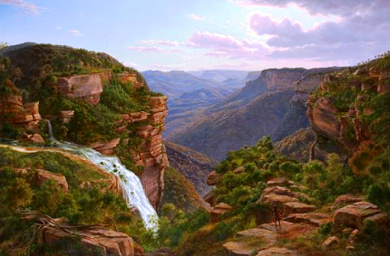
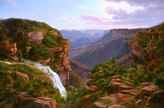
The Weatherboard Creek Falls. Eugene Von Guerard 1862
Despite Governor Brisbane renaming the falls to “Bougainville Falls” in 1825 to honour the leader of a French scientific expedition at that time, the public began to use the name “Weatherboard Falls”, after Cox’s 1814 weatherboard store hut built on Jamison Creek, upstream of the falls, and later the Weatherboard Inn, built 1826-29. Most travellers who could afford to stay at an inn stayed here, and many walked out to see the falls and the valley.

Charles Darwin recorded his visit in 1836 in his account of the voyage of the Beagle; he appears to have stayed at the Weatherboard Inn on his outward journey to Wallerawang and Bathurst and again on his return, walking to the falls on both occasions.
The Weatherboard Falls, Blue Mountains.
 JH Carse 1876
The name “Weatherboard Falls” began to be replaced by “Wentworth Falls” following the renaming of the railway station in 1879. The falls became the centrepiece of the reserve established there, formerly administered by a local trust, then by the Blue Mountains City Council and now by the National Parks and Wildlife Service. More will be said about this in a later blog entry.

Here are some useful sites you can visit. Firstly, from the Wild Walks site, covering the track to the top of the falls via Fletcher’s Lookout, then the Undercliff Track and finally the Princes Rock track here, here and here .

Wentworth Falls February 2013
The photograph of Wentworth Falls in extreme flood in February 2013 comes from this article here.

Here are two interesting videos. The first shows the falls in flood here and the second in strong wind here 

Finally, my own You Tube site, which includes a video on a walk to the falls via Fletcher’s Lookout, returning via the Undercliff and Princes Rock tracks here

The two paintings illustrated are on display in the National Gallery of Victoria, Melbourne.


The Weeping Rock, Wentworth Falls. June 1958

Thursday, 10 October 2013

WALL'S CAVE AND THE UNDERGROUND RIVER, BLACKHEATH BLUE MOUNTAINS AUSTRALIA

WALL'S CAVE AND THE UNDERGROUND RIVER

BLACKHEATH BLUE MOUNTAINS AUSTRALIA

It’s a privilege to be able to visit this interesting spot in the Blue Mountains. For years access was not permitted because the place lies within the catchment area of Greave’s Creek Dam, which supplies water to towns within the Sydney Water region. In fact it is a short distance below another dam on the same creek. This explains the strict conditions imposed on those visiting the spot.
"Path to Wall's Cave" Kerry & Co.
Powerhouse Museum

 Quite apart from the beauty of the location, there is the added interest of the indigenous history of the Cave (actually a large sandstone overhang rather than a cave). You can read about this in “Blackheath Today From Yesterday” published by the Rotary Club of Blackheath, pages 143-144. If you can’t get hold of a copy of this fine book, go to this site   where you will find photographs by JC Merriman. Read especially the comments on geology and archaeology.
It would appear that the spot was discovered by a Mr Wall who actually owned the land at the time; this happened around 1892. As things turned out, access was easier from Medlow Bath in those days than from Blackheath, but today no other route is permitted than that specified by Sydney Water, which is to go to the end of Wall’s Cave Road Blackheath (off Evan’s Lookout Road) and then stay on the track down to the creek, returning the same way.  The image on the right is from the Evening News (Sydney) 21 December 1901 (courtesy of Trove).     I can remember visiting the place several times between 1950 and 1970, but whether we were there legally or not I don’t know. My uncle owned property nearby in the 50’s so we would have started from there.

I’m sure you will enjoy a visit to this special place. Allow an hour or so and obey all signage.

View my Blue Mountains videos on my YouTube site here . This includes a video on the Wall’s Cave and the Underground River, found here


Monday, 26 August 2013

THE KATOOMBA FALLS RESERVE, BLUE MOUNTAINS NEW SOUTH WALES AUSTRALIA

THE KATOOMBA FALLS RESERVE

BLUE MOUNTAINS NEW SOUTH WALES AUSTRALIA

The Katoomba Falls Reserve has been a central part of the “Katoomba experience” for 130 years. Its proximity to Scenic World guarantees that the flow of visitors will continue unabated. So far as I can tell, the falls and surrounding bushland are part of the Blue Mountains National Park while the reserve itself (ie the adjacent picnic and park lands etc) is administered by the Blue Mountains City Council. Both have a continuing battle to keep these areas attractive to visitors and yet maintain their conservation and scenic value.

It appears from the Sydney Morning Herald of July 7th 1880 that the reserve was established on June 4th that year. It would have included the area around the falls themselves, no doubt, as well as the more level ground which we now think of the as the Katoomba Falls Reserve. From then on, sundry improvements began to be made and the area developed as a picnic ground. For example, we read in the Nepean Times of Saturday 29th October 1887 that the local Congregational Church was to hold a Sunday School picnic there the following Saturday.
Railway picnics were great events in those days, bringing NSW Government Railway employees from far and wide for a day’s fun and games. The SMH reports of the picnics of 1912 and 1913 make it clear that crowds of 2000 people attended. The town council was criticised for not making better provision for such numbers. It is a subject worth reading about in Trove, and it's apparent that both Blackheath and Mt Victoria benefited from similar large assemblies.
The camping ground in 1958
At some point the town’s showground was established on the reserve, before moving to its present site around 1926. From that time the NRMA came onto the scene wanting to convert the showground site into a camping area. This was done and the site became a very popular venue in the 1930’s. I can only remember the place from the early 50’s but I am sure those early campers would be amazed at the facilities that are provided for visitors today. It is now known as the Blue Mountains Tourist Park and the website may be found here

Cricket has been played at the reserve for a long time too. We read in the “Blue Mountain Echo” of Friday 2nd December 1910 of plans to set up a proper cricket ground there. Today there are two and the second one also serves as an off-leash dog area every morning.
I have copied the comment below from the Orphan Rock blog, as it is also relevant here.
"If you consult the map on page 251 of The Burning Mists of Time, you will see that by 8th June 1880, North had already given the land for Katoomba Park, basically all that land on the ledge from Katoomba Falls around to and including the Orphan Rock.
Access to the Rock was stopped in 1974 when a mudslide obliterated the access track, and BMCC never repaired it. I think they took it as an excuse to remove some more track maintenance from their books.
In 1998 I took the Mayor and the Head of NPWS up to the top of the Rock to see if it could be re-instated. At the time there was an issue as to whether Council or NPWS "owned" the Rock. Nothing ever came of it.         Philip Hammon June 2014"
 There are three main picnic areas at Katoomba Falls Reserve and on any day, sunny or not, there are always people there making use of this excellent park.
View my Blue Mountains videos here. The one dealing with Katoomba Falls Reserve is here 
The writer at Katoomba Falls camping area June 1958