Search This Blog

Wednesday, 7 August 2019

1938 Map (Part 26): WOODFORD - WILSON GLEN - SWIMMING POOL - WOODFORD
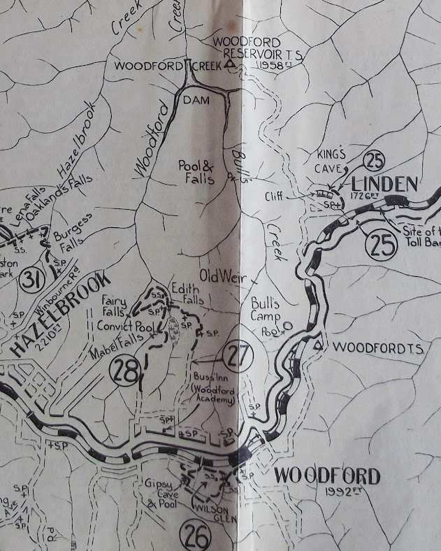
1938 Map (Part 26): WOODFORD - WILSON GLEN - SWIMMING POOL - WOODFORD

The places visited on this walk are part of a reserve set up as a memorial to Mrs Thomas M Wilson of Woodford in 1934. The story of the opening may be found here. It's from the "Katoomba Daily", 7th April 1934.
NOTE: The memorial park became inaccessible from the highway during road widening some years ago. The footbridge over the railway line is still there. Keith Painter has released a "Pocket Pal" booklet on this area

The monument at the entrance to the reserve

Saturday, 3 August 2019

1938 Map (Part 25): LINDEN TO KING'S CAVE AND RETURN

1938 Map (Part 25): LINDEN TO KING'S CAVE AND RETURN


There are many similar photographs to be found using Google
This looks like a straightforward walk. The sandstone hereabouts is prone to forming rock shelters (not caves). This is the well known Hawkesbury Sandstone, which does not occur beyond Woodford.

There is a very thorough heritage description of King's Cave here: https://www.environment.nsw.gov.au/heritageapp/ViewHeritageItemDetails.aspx?ID=1170704
See also this video from "Ask Roz":


Friday, 12 July 2019

1938 MAP (PART 24): FAULCONBRIDGE - SIR HENRY PARKES GULLY, VICTORY TRACK AND CLARINDA FALLS - SPRINGWOOD

1938 MAP (PART 24): FAULCONBRIDGE - SIR HENRY PARKES GULLY, VICTORY TRACK AND CLARINDA FALLS - SPRINGWOOD


This is basically the same route as in Parts 20 and 21. See these blogs for more information.


Tuesday, 9 July 2019

Monday, 8 July 2019

1938 MAP (PART 22): SPRINGWOOD - NORTH SPRINGWOOD - HAWKESBURY LOOKOUT AND RETURN

1938 MAP (PART 22): SPRINGWOOD - NORTH SPRINGWOOD - HAWKESBURY LOOKOUT AND RETURN

What a lot has changed along this route since 1938! I doubt that many people would choose this walk today, preferring to drive to the lookout, which is, after all the focal point of the walk.
Check out these links 
Sunrise at Hawkesbury Lookout: https://www.youtube.com/watch?v=q8yBFOpsIl0


Friday, 5 July 2019

1938 MAP (PART 21): SPRINGWOOD - SASSFRAS GULLY - VICTORY TRACK - FAULCONBRIDGE

1938 MAP (PART 21):  SPRINGWOOD - SASSFRAS GULLY - VICTORY TRACK - FAULCONBRIDGE

As in most of these map extracts, there is quite a bit of overlap with nearby walks.
While is Faulconbridge, you should visit the Prime Ministers' avenue of oak trees and Sir Henry Parkes' grave.


Wednesday, 3 July 2019

1938 MAP (PART 20): SPRINGWOOD - BEE FARM ROAD - WIGGINS TRACK - VICTORY TRACK - FAULCONBRIDGE

1938 MAP (PART 20): SPRINGWOOD - BEE FARM ROAD - WIGGINS TRACK - VICTORY TRACK - FAULCONBRIDGE

With this walk we move further west, to Faulconbridge. The early part is over the same tracks as previous walks, but the Victory Track takes us into new territory.


The "Victory" in the name of the track suggests that it was so named after World War 1. However the track appears to have been constructed in the time of Henry Parkes, who lived at Faulconbridge in those days. Clarinda was his wife (died 1888) and the waterfall along the track was named for her.
There are many videos and bushwalking reports about the Victory Track. Here are a few.

Victory Track solo overnight hike:  https://www.youtube.com/watch?v=H9_5rRBhgi8

Faulconbridge to Springwood: https://www.youtube.com/watch?v=MOvgcQ1_JDk