Search This Blog

Sunday, 5 October 2014

THE GRAND CANYON BLACKHEATH BLUE MOUNTAINS NSW AUSTRALIA

THE GRAND CANYON BLACKHEATH BLUE MOUNTAINS NSW AUSTRALIA

Blackheath’s Grand Canyon is one of the Blue Mountains’ icons. The track through it was opened by the Premier of NSW (Mr JH Carruthers) in February 1907. This was a period when the competition between the Blue Mountains communities to attract tourists and their spending money was at a peak. Blackheath, Katoomba and Wentworth Falls in particular were constructing new tracks and lookouts and the Grand Canyon track is one of the best.
Walking conditions were a lot tougher in those days. Ladders, where required, were constructed out of bush timber on the spot. Steps were hewn out of the sandstone along hundreds of tracks. Lookout railings were made of whatever could be found cheaply, often
bush timber but sometimes old water pipes and odd bits of scrap iron were called into service.
While many well-made steps from those days remain in the Grand Canyon, the rough and ready railings and ladders have gone. In recent years, the National Parks and Wildlife Service has done a remarkable job replacing steps, ladders and railings while preserving the wild character of this beautiful place.
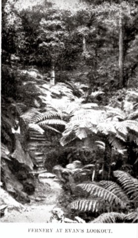
At the time the track through the canyon was completed, it linked up several existing tracks – at the Fernery on the Rodriguez Pass (just above Beauchamp Falls), at Neate’s Glen and at Wall’s Cave.
The Tunnel
 The Wall’s Cave connection was severed years ago by the construction of a water supply dam on Greave’s Creek so that today the round trip takes in Evan’s Lookout, the descent to the canyon via the Fernery, the canyon proper, the ascent through Neate’s Glen and the track alongside the road back to the lookout. There were also connections with roads built from Medlow Bath in the heyday of the Hydro Majestic Hotel, but these have become obscure with the passage of time.
When you read old newspaper reports, it is extraordinary to discover how many people have been lost or injured in the vicinity. There have also been a number of fatalities. There are numerous complaints about poor signposting leading to visitors 
getting lost, though you could hardly say that about today’s track.
Going Down?
A modern hazard for some is the rise of canyoning, a sport which takes intrepid groups down into the narrow and often water-filled places which abound in parts of the Blue Mountains. The Grand Canyon, where Greave’s Creek vanishes into the depths for some considerable distance, is one of the best known, so do not be surprised if you encounter canyoners wearing wet suits and carrying ropes as you pass through on the walking track.
Here are some links to sites which will help you appreciate this exciting walk even more.
My video is here, made on a walk in July 2014. A video produced by the National Parks and Wildlife Service may be viewed here. Another, this time of a canyoning trip, may be found here

  From the Sydney Morning Herald, 18th February 1907.
"The Premier, in reply, said he took a great interest in developing the traffic to the tourist resorts. New South Wales was the best of all the States. The people did not recognise that they had the best climate and scenery in Australasia at their own doors. He was glad to see the trustees had done good work with limited means. He appreciated the beautiful canyon, and hoped it would be visited by thousands of people."


Wednesday, 24 September 2014

THE NATIONAL PASS WENTWORTH FALLS NSW AUSTRALIA

THE NATIONAL PASS WENTWORTH FALLS 
NSW AUSTRALIA

The Cliff Ledge section of the track
So much has been written about this famous walk, and so many photographs taken, that it almost seems unnecessary to add to them. However, this is my own experience of the Blue Mountains that I am writing about, so I make no further apologies.
My earliest memories of the National Pass go back to a time just after World War 11, possibly before my father began working at Wunderlich’s brick and tile factory in Sydney, which would place it in 1945. The only thing I can actually recall is being carried across the shaky and dangerous bridges at the bottom of the Falls. Goodness knows when the last repairs had been made to them.
Much more recently, my own children did the walk 
Roland, Yvonne and Lyndall Paix 1978
at a tender age in 1978. On my recent walk, I encountered numerous seniors, so if you’re getting on in years don’t let your age be the deciding factor. True, there are lots of steps to get down into the valley and return, but just take these slowly and all should be well.
The round walk easily divides into 5 sections and each one has an interesting history of its own.
The best place to find car parking is at the Wentworth Falls Picnic Area, and since your walk is going to take around 4 hours it makes sense to arrive early to be sure of finding a spot. Carry your lunch with you and enjoy it along the track. Make sure you have plenty of water as well, 
Empress Falls Valley of the Waters
since drinking from the many streams you will encounter is not  recommended. The alternative car park at the Conservation Hut is often filled up by patrons enjoying the fine food on offer there.
Sylvia Falls Valley of the Waters


I recommend that you take the Short Cut Track from the bottom car park, which is a pleasant walk of 15-20 minutes leading to the Conservation Hut. Historically, there has been a track between these 2 areas for over 100 years, because it made round trips possible.  This is Section 1
Section 2 is the magnificent descent into the Valley of the Waters. If you love the sound and sight of falling water, this place is for you. Take the steps and ladders slowly and savour every moment in this magical place. People like you have been coming here for 120 years and it isn’t difficult to see why.
Section 3 (the first part of the actual National Pass section) begins at the final creek crossing just above Lodore Falls and takes you onto the extraordinary cliff ledge leading around to the bottom of the first drop of Wentworth Falls. Before 1906, it was possible to go further down into the valley and follow up Jamison Creek to the bottom of the second fall, but it was only the completion of the ledge track that allowed easy access to bottom of the first 
fall. All along this section (and up the Grand Stairway) the National Parks and Wild Life Service has installed commemorative plaques and information panels telling of the restoration of the track and the environment through which it passes. These are a valuable addition to your walking experience.
The area immediately below Wentworth Falls is like a magnet which draws lots of people to it, many of whom descend the stairs and return the same way. If you want to find this place peaceful and quiet, then avoid school holidays and weekends.
Materials used during the restoration of the track
Section 4, the stone stairway up the cliff face,  is surely the highlight of the National Pass adventure. Completed in 1908, it made the round trip as we know it possible. You can discover lots about this magnificent feat of engineering in many places, but here are two of the best. The first I will simply call “a very special presentation”, which you may access here. The second is the NPWS site which is also excellent.
Den Fenella Falls
Section 5 consists of the track from the creek crossing to the Wentworth Falls picnic area. This route, more or less, has been in use for 150 years.
My own video of this walk may be found here. Unfortunately, my camera battery failed just after I  had passed behind Den Fenella Falls, so this part of the trip is not included. One day I’ll do the trip again (and again, if my body permits me) and there will be a new video to record the event.
NOTE: THE PASS IS CLOSED DUE TO ROCKFALLS AS AT AUGUST 2019 AND HAS BEEN FOR OVER A YEAR.


Vera and John Paix on the Grand Stairway June 1958