Search This Blog

Thursday, 30 January 2014

ECHO POINT AND THE THREE SISTERS KATOOMBA

ECHO POINT AND THE THREE SISTERS KATOOMBA


The Three Sisters around 1900
A million photographs have been taken and a million words written about these two famous places, which are linked by the most heavily used path in the Blue Mountains. Rather than repeat a lot of this information, I’ll pick out a few details and expand on them.
The first mention of Echo Point I have been able to find is in the Sydney Morning Herald of 31st August 1891, which mentions the intention of the reserve trustees to construct fences in the most dangerous places around the cliffs at “Echo Point”. I suspect that the locality came to prominence when the Chief Justice of NSW, Sir Frederick Darley, built his country residence (Lillianfels) nearby in 1889. Land sales along Lurline St took place the same year so there must have been a road of some sort to the vicinity.

Prior to this, the tourism emphasis was on Katoomba Falls. The presence of the coal mine there would have meant that there was road access, especially as quite a village already existed near the present day Katoomba Falls Reserve.

Echo Point today is by far the most visited spot in the Blue Mountains. The lookouts there have been through many stages of development since 1891 and the principle feature that tourists are drawn to is, of course, the famous Three Sisters.

One reference in particular throws light on the early history of this spot, which was usually seen from afar and was often mentioned by visitors to the cliff line around Katoomba Falls (though the Orphan Rock which was much closer drew even more attention). This is a fascinating document from a journal called “The Australasian Sketcher with Pen and Pencil” (Melbourne, Vic) for Saturday 5th June 1880. You can download the article here                                                                                                                          
The critical words are these “Continuing to the eastward, the Triasaxa point is the next object of interest. It is commonly called "The Three Sisters" and from the distance has a remarkable resemblance to a cathedral”. “Tria Saxa” basically means “three stones”, though who gave this name or when I cannot say; most likely it would have appeared on a map and was given by some classically educated mapmaker. It was easy for “Three Sisters” to displace it and was last heard of more than a century ago.

One of the significant events which occurred here was the opening of the Giant Stairway in 1932, for which occasion the path connecting Echo Point and the Three Sisters was vastly improved. The lookout at the top of the Stairway already existed and was commonly called “Three Sisters Lookout”, though its correct name is “Lady Game Lookout”. The plaque on the archway just before the lookout reads as follows: “Three Sisters Giant Stairway Officially Opened by Hon. B.S.B. Stevens, M.L.A. Premier of N.S.W. 1st October 1932”. At the bottom of the plaque (in smaller writing) is a second inscription reading “Steps Cut by Ranger McKay”. We’ll consider the second inscription in a later article.                                                                                                                  
Official party. Photo courtesy of Blue Mountains City Library
1932 was an exciting year in NSW politics. The Great Depression was making life difficult for almost everyone. The Sydney Harbour Bridge was completed early in 1932 and newspaper speculation was rife as to who would officially open it. One says the new Governor General Sir Isaac Isaacs, another the NSW Minister for Works, Mr Davidson. In the end, the opening was scheduled for Saturday 19th March. Both the aforementioned gentlemen were indeed present. The Governor of NSW, Sir Philip Game, unveiled a commemorative plaque and the bridge was declared open by the Premier of NSW, the Hon. JT Lang. He was about to cut the ribbon when an extraordinary thing happened. A man on horseback (Captain Francis Edward de Groot) rode up and slashed the ribbon with his sword, declaring “I officially declare this bridge open in the name of the decent people of New South Wales”. Now there is a lot more to this story, of course, but it highlights the huge differences of opinion between the Labor Party of Premier Jack Lang and the right wing sentiments of “The New Guard”, to which de Groot belonged. For a good account of the bridge opening see here.

John and Sue at the beginning of the Three Sisters path 2013
By the time of the opening, the financial crisis in NSW was worsening and the Premier declared that his government would refuse to pay the interest or make repayments on foreign loans. The Federal Government (headed up by Prime Minister Joseph Lyons) declared that this was illegal. Matters came to a head on 14th May, 1932, when after repeated refusals by Mr Lang to change his mind, the Governor of NSW, Sir Philip Game, dismissed the NSW government and appointed Mr Bertram Stevens, leader of the opposition United Australia Party, as Premier. This was followed by an election on 11th June, at which Lang was soundly defeated.

Meanwhile, back in Katoomba, preparations were going ahead to open the Giant Stairway. Sir Philip Game was being mentioned as a likely candidate, but in the end the Katoomba Council played it safe and went with the new Premier, Mr Stevens. So what was supposed to be on the vacant part of the plaque? I’m guessing that it would have referred to the Governor opening the Stairway and the lookout being named after his wife (which it still is). One day we may know. There is an account of the opening here.

Sir Philip Game held on for another two years as Governor. For some members of the community, he was fair game. For others, the game was well and truly up.

My video of the walk may be found here.  

The Three Sisters from Echo Point 1958

Additional information added November 22nd, 2015
I've come across a slightly earlier reference to the Three Sisters than the one above. It's from the "Sydney Mail and New South Wales Advertiser" for Saturday 29th May 1890 (page 988). You may read it all here. The article is essentially the same as the one quoted above (from The Australasian Sketcher with Pen and Pencil”); however it also includes a delightful sketch of scenery, including the Three Sisters, making this the earliest illustration I've yet found of this landmark. The illustration may be in the later reference as well, but a brief search failed to find it. Here it is for your enjoyment.


Wednesday, 29 January 2014

HASSAN’S WALLS LITHGOW WESTERN BLUE MOUNTAINS

HASSAN’S WALLS LITHGOW 
WESTERN BLUE MOUNTAINS

Anyone driving on the Great Western Highway between Hartley and Lithgow will have noticed the cliffs of Hassan’s Walls above them. They are outliers of the same Triassic sandstone familiar to everyone in the western Blue Mountains.
Like Govett of Govett’s Leap at Blackheath, people ask “Who was Hassan?” Answers will vary: he was an escaped convict (there was a convict stockade below the Walls in the early days), he was a character in the Arabian Nights, he was an Arab stockman.
The right answer seems to be that Governor Lachlan Macquarie named the Walls during his trip to Bathurst in 1815 on the newly built Cox’s Road. It is said that they reminded him of the Walls of Hassan in southern India, but whether this is true or not I cannot say. However the name came to be given, it has certainly stuck.                                                                                                                               
1895 newspaper quote
The Walls have always been a tourist attraction to visitors and the people of Lithgow. The area was made a Reserve as long ago as 1895; however it was the work of James Padley during World War 1 that laid the foundation for the Reserve as we see it today. Even a brief look at Trove (newspaper files) reveals the extent of the problems – vandalism, littering, stealing native plants
Illustrated Sydney News February 7th 1889
and just general apathy. Nor have these problems ceased in the district. The Zig Zag Railway has been suffering from constant vandalism and theft for years, most likely carried out by local residents, perhaps the descendants of the Hassan’s Walls vandals of earlier years.
Lithgow City Council is in the process of having a boardwalk, interpretive signs etc constructed right now (January 2014). No doubt these will be great assets and improve the visitor’s experience greatly. However, history shows that the graffiti “artists”, vandals and thieves won’t take long to get up there to try to spoil that experience.
The area has an incredibly varied fauna which includes plants scarcely known elsewhere. Please protect this environment – no rubbish, keep to made tracks and the boardwalk and definitely no fires!                                                         

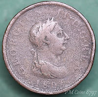
Something needs to be said about the prominent rock outlier so noticeable during the drive around the “Forty Bends” at Old Bowenfels. Right at the end of a ridge, you can hardly miss the likeness to a man’s head. I’ve been aware of it for as long as I can remember. The old name for this erosional feature is “King George’s Head”, though I have heard it called “Indian’s Head” locally as well. Let’s stick to the traditional name.
So why King George’s Head? The king referred to is undoubtedly George III and the only likeness most people in Australia would have seen of the king was on his coinage. He faces right on his coins, as does the rock when seen from the Highway (which rules out Georges II and IV who face left on their coins). The best known image of King George (who reigned from 1760 to 1820) is on the celebrated "cartwheel penny” of 1797, which circulated widely in the colony. I believe this is the origin of the name.
NOTE ADDED 11th November 2017.The 1806 penny, especially a worn example (which was the usual condition of Australian circulating coins) is more likely to have been in the pockets of people in those days. They remained in circulation right up to the gold rush days.
You will find a fascinating account of Lithgow in this article from the Illustrated Sydney News February 7th 1889) from which the pictures above come. The article also mentions King George’s Head. Click here.
A good article about the development of the Reserve in James Padley’s time may be found here.
You will find my video here and another (Holiday Hunter) here
NOTE ADDED 28th March 2015 - report from the Lithgow Mercury on a recent landslide here.


Friday, 24 January 2014

PRINCE HENRY CLIFF WALK: KATOOMBA CASCADES TO ECHO POINT

PRINCE HENRY CLIFF WALK: 
KATOOMBA CASCADES TO ECHO POINT

Cliff View Lookout
The Prince Henry Cliff Walk was named for Prince Henry, Duke of Gloucester, third son of King George V. He neither saw the track nor opened it, but was “in the right place at the right time” (so to speak). He was visiting Australia in 1934 when the first stage of the track was opened. It was a popular thing in those days to name places after royalty and the Duke happened to be the chosen one this time. You can see a photograph of the Duke at Katoomba Station by clicking here.

When he returned to Australia in 1945 to serve as Governor-General he was well received; by this time he was the brother of the king, George VI. The royal family had become very popular during  the war because of their support for the people of England who suffered so much, particularly during the Blitz.

Sphinx Rock
Sydney Morning Herald
The section of the Walk from Katoomba Falls to Leura Cascades was opened at Echo Point by the Minister for Local Government, Mr ES Spooner. It is one of a number of enterprising tourist paths opened around the same time – the Orphan Rock ascent, the Giant Stairway and the Projecting Platform at Echo Point being the others. Coupled with the new floodlighting, the Cliff Drive and the development of the Scenic Railway, this must have been a boom time for Katoomba!

Before the track was developed there were already a number of popular spots along the route: the Katoomba Cascades, Cliff View Lookout, The Sphinx rock, Lady Darley Lookout and Echo Point. Now it was possible to get a bus to either end and walk between the two in less than hour. Lots of people do this every day, just as they have been doing for the past 80 years. You have lots of options when it comes to returning to your starting point. I decided to follow the road and rejoin the walk at the Skyway terminal near Cliff View Lookout. 

Callicoma (black wattle)

The area before the Cliff Walk was constructed
My video of the walk is here

The area in 1952 (much the same today)


Wednesday, 22 January 2014

FURBER STEPS, KATOOMBA FALLS BLUE MOUNTAINS AUSTRALIA

FURBER STEPS, KATOOMBA FALLS 

BLUE MOUNTAINS AUSTRALIA

Original ladder: State Library of Victoria
When the Federal Pass was completed in 1900, linking Leura Falls to Katoomba Falls, it was hailed as a great achievement, which indeed it was. Tourists no longer had to visit the two sights separately – they could now descend into the valley at either end and walk between the two.

However, the descent of the lower cliffs at Katoomba was made in part by wooden ladders which many visitors would have found rather daunting in such an exposed position, especially when you look at old photos and see the clothing visitors wore in those days. The answer was to carve a set of steps into the cliff to replace the most dangerous ladders. Similar steps had already been carved into the cliffs at Blackheath and Wentworth Falls. The government surveyor who arranged funding for their construction in 1908 (at a cost of 140 pounds) was Thomas Frederick Furber. This sum might seem tiny to us, but to the volunteer Trust controlling the area it must have seemed enormous and no doubt they were profuse in their thanks to Mr Furber and the NSW government.

Even so, many visitors sought a free ride on the coal trucks ascending the cliff nearby and this ultimately led to the establishment of the Scenic Railway and Scenic World as we know them today. There are still lots of people who descend into the valley via the steps but you don’t see many going the other way!                                                                                                                                                   
View from Lyne's Point 1957
The official opening of the Federal Pass took place on 3rd November 1900, just a few weeks before the Federation of the six Australian States took place on 1st January 1901, hence the name. The Premier of NSW, Sir William Lyne, officiated. Lyne drew the line after climbing down to the bottom of Leura Falls. He then returned to Katoomba but many others went on the complete the entire walk. All assembled at Katoomba Falls Reserve for afternoon tea and speeches and an official banquet was held at the Carrington in the evening.

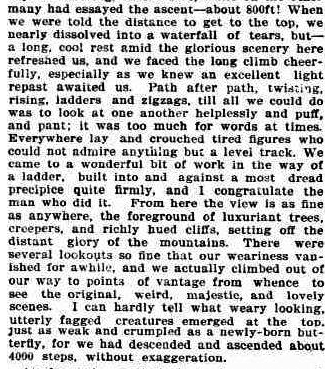
There are many newspaper reports of this event; you will enjoy the one in the Evening News (Sydney, NSW) of Monday 5th November 1900, page 8. Here is an extract referring to the ascent to Katoomba Falls, which was obviously the hardest part.

From Evening News 5/11/1900
Back to Furber and the steps. There is a lot of information about TF Furber in an article compiled by The Institute of Surveyors NSW Inc. beginning on page 139. You will find this reference here. This is the origin of the photograph. He was clearly a man of vision dedicated to his work and the good 
Furber Steps, newly built

                                                 of the community. However the construction of the steps came about, this is a place which remains exciting to visit and, if anything, the visitor comes to the bottom all too soon. With the views, the element of danger and the knowledge that you don’t have to climb up again, it is yet another place “not to be missed”.

Furber Steps today from Cliff View Lookout
You will find my video of this walk here.                             


Friday, 17 January 2014

THE HARTLEY GRANITE, BLUE MOUNTAINS NSW AUSTRALIA

THE HARTLEY GRANITE, 
BLUE MOUNTAINS NSW AUSTRALIA

From the 1875 Heritage Map
At Mt Victoria the Great Western Highway leaves the level of the Blue Mountains plateau and descends into the valley below via the Victoria Pass. From top to bottom you can see the sedimentary layers of the Sydney Basin, first the Narrabeen Group (Triassic) and then the Illawarra Coal Measures and Shoalhaven Group (Permian). Once the valley floor has been reached, cuttings reveal further Sydney Basin sediments before the road begins to descend again towards Hartley.

Granite outcrops McKane's Falls road
It is at this point that the first granite outcrops may be seen and it is noteworthy that the elevation of the first granite is similar all over the northern part of the Hartley Valley and adjoining areas. This is because the Sydney Basin sediments here are resting on an old land surface mostly made of granite which was itself formed as an intrusion (in the Lower Carboniferous period) into older Devonian and Silurian sediments. See the blog entry on the Unconformity at South Bowenfels here for more information.

Normal granite, somewhat weathered
Aplitic granite
The difficulty you will experience in examining exposures of the granite is essentially one of access. The land  around is all private property so you will be reduced to looking at road cuttings, for the most part. Parking alongside the Highway or the Jenolan Caves Road at Hartley is not recommended and in any case there is rarely anywhere to park near a cutting where the best exposures are.
Here are three suggestions, based on approaching from the direction of Sydney.  
Firstly, Hartley Village historic site. You will not be very popular with the National Parks and Wildlife Service if you start hammering the natural outcrops here, but at least you can see the typical granite tors on the hillside from a safe place. What you will see is that the granite consists mainly of quartz and pink orthoclase felspar (I prefer this spelling to feldspar) with lesser amounts of greenish plagioclase felspar, biotite mica and miscellaneous other minerals.

This evening I looked up my first field notebook from August 1959 when I was 17 and just beginning to study geology. I had ridden my bike from Lithgow and examined many outcrops along the way. Life was somewhat simpler then! Here is my observation at Hartley.
Near 2nd church Hartley. Many granite boulders freshly blasted. Very big crystals of pink feldspar. 
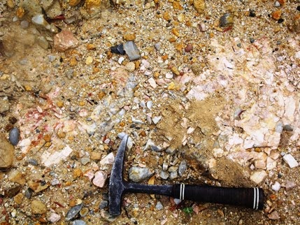
Orthoclase phenocrysts weathering out
One boulder covered with fern-like growths of a silver mineral (hardness 4) and a brassy one (hardness 6).” Back to the present. Perhaps that boulder or one like it is still there. What might the minerals have been? The pink feldspar is orthoclase, in the form of phenocrysts, which is typical of the Hartley Granite. You will find it in every outcrop, though not always as larger crystals. The fern-like growths are dendrites, a form which is typical of minerals which crystallise in confined spaces along joints. They probably formed this way in the last stages of crystallisation of the granite as the rock cracked and watery mineral solutions percolated through it. The silver mineral could be pyrrhotite (FeS), sphalerite (ZnS) or perhaps arsenopyrite (FeAsS). The brassy one could be pyrite (FeS₂). Perhaps a reader will locate specimens and let us know what they think. 
NOTE 20th December 2015.There is major road construction going on around Hartley. This has removed parking opportunities almost completely except at Hartley village. Lots of fresh granite has been exposed and then covered up with concrete. This may be good for roads, but it's certainly bad for the study of geology.

Pegmatite outcrop, River Lett Hill
Secondly, an old quarry on the left of the highway about 200m past the Jenolan Caves turnoff. There is somewhere to park. The quarry is through the fence. This is best accessed if you are in the left lane and not so safe if you are coming down the River Lett Hill instead of going up. You can get clear of the traffic here and have a good look around. The place has become a dumping ground for all sorts of rocks and rubbish as well as a parking area for machinery, but there are some outcrops of quartz-orthoclase pegmatite on the upper side. I guess this is what was being quarried, probably for the extraction of the orthoclase which has lots of uses in industry. There are many small outcrops like this around Hartley. Few have been very productive. You can read about the industry and the origin of the pegmatite in the references given below.

Thirdly, along McKane’s Falls Road. This is a narrow, sealed road linking the Great Western Highway and the Jenolan Caves road. It turns off to the left towards the end of Hassan’s Walls at Old Bowenfels, several kilometres after the top of River Lett Hill, immediately after the new road constructions. Parking isn’t easy, but there is a reasonable spot on the right 3.1 km from the highway. From here you can see granite outcrops in the nearby paddocks and especially 
Outcrops near Mt Blaxland
towards Mt Blaxland on the left. Look out for aplite (microgranite) outcrops and areas with orthoclase phenocrysts weathering out of the granite and coarser pegmatites. From here you can continue on to the Jenolan Caves Road, crossing Coxs River just below Mt Blaxland which was the terminal point of the 1813 expedition led by Blaxland, Lawson and Wentworth.

Orthoclase from pegmatite
These early European explorers noted the outcrops of granite in the area, as did George Evans who followed up on their discoveries. William Cox’s road builders passed though here in 1814/15 and made good use of the rock for culverts and embankments.       Later visitors included some of more scientific bent and the area formed part of the first detailed geological map of the country west of the Blue Mountains (1875). Small quantities of gold and other metallic minerals were discovered, but the granite itself and the orthoclase in it's pegmatites has always been the resource of greatest value. Austen Quarry is extracting large quantities of these materials today and you will see it from a distance on the right as you return towards Hartley along the Jenolan Caves Road.

These references are all downloadable. Some of them have been relocated and finding them is something you will have to through Google or DIGS. See my blog entries on how to do this from Trove and DIGS.

The Geology of Sydney and the Blue Mountains (J Milne Curran 1899). Trove. Tick “Books” “online” and use the keywords “Curran” Geology” and “Sydney”. You will find several downloadable versions. Mineral Resources 26 Felspar in NSW (1917). DIGS Report Number: Mineral Resources 26.

Mineral Industry NSW Feldspar (1969) DIGS Report Number: Industry 15.

The Gap silver-lead-zinc mine, Hartley, near Lithgow (1970). DIGS Report Number: GS1970/293

Geological Map of Hartley, Bowenfels, Wallerawang, Rydal districts (1875). DIGS Report Number: Heritage Map H0252

Metallogenic Map Sydney (1980). DIGS Report Identification Number: R00027967

From the Sydney Metallogenic Map