Search This Blog

Monday 4 November 2024


 LITHGOW DISTRICT RAILWAY STATIONS: 3 NEWNES JUNCTION


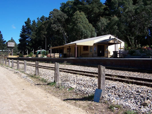
Newnes Junction Station 1908


The years around 1910 were rather busy for the Great Western Railway. The 10 Tunnels Deviation to eliminate the great Zig Zag was being built, deviations of the main line to accommodate this were being constructed and the line was being duplicated.  Duplication was completed to Mt Victoria. New platforms were erected on most stations, between Mt Victoria and Glenbrook, the one at Bell being typical.

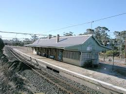
A branch line from the oil shale mines at Newnes in the Wolgan Valley was completed in 1907. The Newnes Junction station shown above is on the the as yet undeviated main line to Lithgow, which was still a single track. The present station was built on the new line about 1910 and is a few hundred metres south of the original platform.

Friday 4 October 2024

 LITHGOW DISTRICT RAILWAY STATIONS.  

2. BELL. 

The locality we know as "Bell" was named for Archibald Bell Jr who, in 1833 located the route across the Blue Mountains from Kurrajong which is usually known as "Bell's Line of Road". 

The construction of the railway line from Sydney involved the building of the Lithgow Zig Zag, opened in 1869. The entire area was rugged bush land at the time and no stations were provided between Mt Victoria and Clarence, where the descent into the Zig Zag began.

What happened next was intimately bound up with the settlement of Mt Wilson, a fertile plateau 14 km from the site of Bell.

Surveyor William Romaine Govett discovered the plateau in 1838, but it remained wild and inaccessible for another 25 years. In 1862 Mt Wilson was subdivided and put up for sale by the NSW government, but little interest was shown by the public. In 1868 the lots were put up for sale again, this time more successfully. Many lots were purchased by wealthy Sydney families and soon costly homes began to appear in the bush, surrounded by extensive gardens.

The Mt Wilson we see today, over 150 years later, is celebrated for its fine gardens.


The construction of the railway line was the driving force behind this development and no doubt quantities of building materials and tools were soon being dropped off near where Bell's Line of Road meets the railway.
A station was opened at Bell (bearing the name Mt Wilson) in May 1875.
Quotations from the "NSW Railway Guide" for 1881:
 "The distance of Mt Wilson from the railway is about 8 miles by Bell's Line of Road." "In 1875 the sixty-two allotments previously measured, and containing in all about 1,025 acres were taken up by 33 purchasers." "EC Merewether, Mr E King Cox, Mr Wynne, The Hon. JB Wilson, Mr Henry Stephen, others, are the owners of land in this picturesque and beautiful locality."
The station was relocated to its present site in 1889 and renamed Bell. It was reconstructed in 1910/11 when the line was duplicated following the Zig Zag diversion in 1910.


Videos worth watching:
Trains at Bell. Sydney Trains Vlog
Bell Station in Snow 2019. Diesel Dave Trains

Thursday 11 July 2024

LITHGOW DISTRICT RAILWAY STATIONS.                           1. HARTLEY VALE

The locality we know as "Hartley Vale" roughly corresponds to what Governor Macquarie called "The Vale of Clwydd" in 1815. This name has now migrated over the ranges to the eastern end of the Lithgow Valley. "Petrolea Vale" was also used for the locality where kerosene shale (torbanite) was mined. "Kerosene Creek" was applied to the stream draining the main workings.

               
Hartley Vale 1902 (from "Kerosene Shale Deposits of NSW" by J Carne)
Kerosene Shale (torbanite) is widely distributed in the Illawarra Coal Measures in the western part of the Sydney Basin of NSW. It is much less dense than ordinary black coal but was apparently formed in a similar way from vegetable matter, most likely of algal origin. When heated it liberates large quantities of  flammable gas, much of which can be condensed to a liquid which was widely used in lamps before electricity replaced it.
The railway line from Sydney opened at Mt Victoria on 1st May 1868. At first products from the mines went via Victoria Pass to Mt Victoria station by horse drawn trucks. Construction of the Great Zig Zag which took the line down into the Lithgow Valley had been going on for years before the line opened to Bowenfels on 18th October 1869.
The Hartley Vale mining companies constructed a narrow gauge line and a cableway to bring their products to the new railway at what became Hartley Vale Station.
There is an interesting article in the Sydney Morning Herald, Friday 13th April 1866. This is well before the railway was opened to Mt Victoria. "The one great difficulty lies in the matter of carriage. Every ton of mineral must necessarily reach Sydney by the road described in the preceding chapter. (ie via Victoria Pass). This drawback is, however, of a temporary nature.
The great trunk line of New South Wales Railway is in progress within a mile of the works, and will ere long be opened many miles further up the country."
I believe that freight from (or for) Hartley Vale was probably being carried by rail to Mt Victoria before the official opening of the line to Bowenfels in 1869. 
The following information comes from NSWrail.net.
Hartley Vale Station.
1876 Opened. 6  April 1975 Closed.
Consisted of a 200m island platform. On the down side were sidings serving a goods shed. There were
 also exchange sidings for the 1m gauge tramway to the nearby Hartley Vale kerosene works.


2005

The station no longer exists. The only sign of its location is where the tracks still diverge around where the platform once lay."
Song Studies. Bible studies based on hymns and songs
Shoalhaven District Geology.


Tuesday 18 June 2024

VICTORIA PASS BLUE MOUNTAINS NSW

The Victoria Pass (Pass of Victoria) is one of the places on the NSW highway network where traffic can be delayed by sections of 2 lane highway and steep grades.
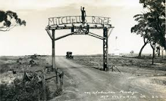
A good starting point in understanding the pass is the monument raised to commemorate its construction. The turnoff to Mitchell's Ridge is on the left (descending) immediately before the traffic control unit.

The reserve was probably used to house convicts during   
the construction of the Pass. Much later it became a camping area run by the NRMA. Today it is a popular rock climbing location. Watch this video on the reservehttps://youtu.be/1vMFnQkSUNQ .

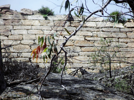
The basic layout of the pass is the same as when it was constructed nearly 200 years ago. The major obstacle which had to be overcome was the deep gully about half way down. This was filled by convict labour and is in good order today. This "bottleneck" is what prevents the highway being expanded to four lanes.
Alternative descents into the Hartley Valley.
The first Europeans to cross the sandstone plateau (the Blaxland, Wentworth and Lawson party in 1813) reached the western end of Mt York, west of the present day town of Mt Victoria. This turned out to be a bad place to descend and over the next 20 years efforts were made to improve it. Major Mitchell located a better route in 1830 which lead to the construction of the Pass of Victoria (1830-38).
Watch this video about Mt York: https://youtu.be/l0galH5HAXo

With the introduction of motor vehicles in the 20th century it was soon discovered that most could not cope with the grade. The local council (Blaxland Shire) constructed an alternative road known as Berghofer's Pass after the Shire President who lived close to the foot of Victoria Pass. You can walk this route and look up at the massive roadworks at Mitchell's Bridge.

Watch this video about Berghofer's Pass: https://youtu.be/wkunvkvzZtQ

The Convict Workers
Not much has been said about the convicts who did the physical work to construct Victoria Pass. Here is a comment written about 50 years later. (Blue Mountains Guide 3rd Edition 1892-93)

Saturday 30 March 2024

 WILLIAM ROMAINE GOVETT

William Romaine Govett (1807-1848), surveyor, was born on 3 October 1807 at Tiverton, Devon, England, the third son of John Govett, surgeon, and his wife Susanna Price, née Owen. He was at Blundell's School, Tiverton, from 1817 to 1820. He was appointed assistant surveyor in the Surveyor-General's Department of New South Wales on 10 July 1827 at £240 a year, reached Sydney in the Asia next December and began work on (Sir) Thomas Mitchell's staff. Part of his work included surveying on the old Bathurst road, during which he discovered Govett's Leap in the Blue Mountains, which was named by Mitchell in his honour. Mitchell was pleased with Govett and described him in a report on the department in 1832 as a wild young man who needed control, who had come to the colony ignorant of surveying but with much natural talent had become perhaps the ablest delineator of ground in the department, and who was remarkably clever at dealing with unexplored country.

In February 1829 Govett was sent to the Hawkesbury River, where many farms required measurement, but in 1833 his career ended abruptly when the department was reduced. Govett returned to England in the Ann in March 1834 with a letter of recommendation from Mitchell to the British government. After his return to England Govett lived at Tiverton, where he wrote several articles on New South Wales which were published in the Saturday Magazine between 7 May 1836 and 2 September 1837 under the title 'Sketches of New South Wales'. They dealt with such topics as the nature of the country he had helped to survey, the habits of the Aboriginals, and life in Sydney; they were illustrated with twelve paintings by Govett, which were later advertised for sale by G. Michelmore & Co.

Govett appears to have undergone a personal crisis after his return and repented of his wild early life, but although he considered going abroad again and making a fresh beginning he did not live long and died on 22 August 1848 in London."

This article was published in hardcopy in Australian Dictionary of Biography, Volume 1, (Melbourne University Press), 1966

From Govett's descriptions it appears that the discovery of the famous waterfall named after him by Sir Thomas Mitchell was not made at what is now "Govett's Leap Lookout" but at the point where Govett's Leap Brook meets the cliff edge near Barrow Lookout. The monument was placed at Govett's Leap Lookout as this is the place where visitors are most likely to see it.

Govett went on to discover what we know as Mt Wilson.

Govett's Leap's location matches the place mentioned by Assistant Surveyor William Romaine Govett in his letter to Surveyor General Major Thomas Mitchell dated 1st July 1831. “The Creek near ‘Blackheath’ after running about two miles and a half falls abruptly after the manner of the cascade at the ‘Weatherboard’ into one of the Gullies of the Grose River; at a point near this fall of water you have a grand view of two cascades, and that break of rock which forms such a particular (feature) in this Survey. Indeed I have not as yet seen a view which shews (sic) so well the character of the mountain feature …”. (Quoted from “Blackheath Today from Yesterday” p 131, edited by Peter C Rickwood and David J West, 2005).  
                                                                           
Govett's Leap from Barrow Lookout
No doubt Govett discovered the waterfall by following the creek we now know as Govett’s Leap Brook, rather than the ridge which ends with the present day Govett’s Leap Lookout. We need to take note at this point that the correct name for the waterfall is “Govett’s Leap” (not the Bridal Veil or Bridal Veil Falls), which name appears to have been given by Mitchell soon after Govett’s discovery. The monument at Govett’s Leap Lookout reads as follows: “This fall of water was named Govett’s Leap from the circumstance of William Romaine Govett Assistant Surveyor first having come upon the spot in June 1831”.

This concise statement of the facts is in stark contrast to the bizarre stories that abounded from the early 1870’s onwards, which had Govett as a bushranger, an escaped convict or convict overseer, a murderer and general vagabond. His “leap” was supposed to have been on horseback over a rocky gully (which he and his horse survived) or over the cliff (in which case they didn’t). Those responsible for promoting tourism in Blackheath could have easily contradicted these wild stories; however it seems that they used them to promote interest in the town and district. Even today poor Govett is seldom shown the respect he deserves.


Wednesday 27 March 2024

 ARCHDEACON FRANCIS BERTIE BOYCE 

OF BLACKHEATH

                                                               (1844-1931)

                                                      Canon Boyce by Julian Ashton

"A good Australian, he was no narrow patriot, and was interested in history, writing on the church of England and some of its notable figures. He was a fellow of the (Royal) Australian Historical Society, and saw history as recounting the development of a moral sense in mankind; in this way, he could account for, and defend, his own reformist activities."

published in Australian Dictionary of Biography, Volume 7, (MUP) 1979 

Boyce's final parish was in Sydney where he spent his abundant energy on helping disadvantaged people. You will need to read the article mentioned above to understand this side of the man.

His holidays and whatever spare time he may have had were spent in Blackheath in the Blue Mountains. He was involved in a wide range of community activities especially those which  were aimed at bringing new residents and tourists.

The Blackheath Council named Mt Boyce after him and there is a monument and picnic area there, just off the Great Western Highway. Perhaps his name is better remembered today since it has been attached to the weather station and truck inspection facility.


Sunday 19 April 2020

JENOLAN CAVES. AUSTRALIAN WONDERLAND by Samuel Cook, 1889


JENOLAN CAVES. AUSTRALIAN WONDERLAND 
by Samuel Cook, 1889


This book is the first thorough account of the Jenolan Caves in NSW, Australia. You can download a copy of it here.
This is chapter 6 (The Nettle Cave) which was one of the few caves which early visitors could enter. Later discoveries of more spectacular caves caused it to be taken out of use as a show cave, but today it is available again as a self guided tour.
See also the slide show which is composed of all the plates from this book.
You may be able to set your reader to read this passage aloud.

CHAPTER VI. THE NETTLE CAVE.
THE Nettle Cave is for the most part a place of twilight. If visitors are incautious in approaching  it they will soon come to the conclusion that it has been properly named, for all around are fine clumps of herbaceous weeds with sharp tubular hairs upon vesicles filled with irritating fluid. The sting of a nettle and the sting of an adder resemble each other, but are yet dissimilar. The adder strikes his tubular fang into his prey, but the nettle victim impinges upon the tubular hair which communicates with the acrid vesicle. 
The Nettle Cave is reached by climbing 170 feet to the left of The Grand Arch, and if in the ascent the visitor be invited to smell a plant with alternate leaves and racemes of not very conspicuous flowers, it would be well for him to decline with thanks. There are some rough cut steps leading to this cave, and on one side is a galvanised wire rope supported by iron stanchions let into the rocks, which makes the ascent tolerably safe. The road runs between two bluff rocks, which for a considerable distance rise almost perpendicularly, and then curve so as to form a segment of a circle some 150 feet overhead. The cave is barred from wall to wall by a light iron gate sufficient to prevent improper intrusion, not ponderous enough for a penal establishment, but sufficiently pronounced to suggest Richard Lovelace's lines " Stone walls do not a prison make, Nor iron bars a cage ; Minds innocent and quiet take That for an hermitage." Descending some of the rough stones and winding along a footpath, the tourist descends into a chamber below a magnificent series of rocks covered with beautiful " formation " from the dripping roofs above. This is called " The Willows," because of the resemblance it bears to the graceful and beautiful appearance of the Salix babylonica, on which in the olden time captive Israelites hung their harps and "wept when they remembered Zion." The entrance to this cave is circuitous. 
First there are some rocky steps to be climbed, and then the road winds through avenues of " willow " formation up to the summit. From this point about 60 or 70 feet down is a funnel-shaped declivity resembling the mouth of an extinct volcano. In some respects it is like the " Blow Hole " at Kiama (a natural fountain, inland, fed by ocean waves which force their way through a water-worn tunnel). Undoubtedly that also is one of the wonders of the world, but some time since it was utilised by the local corporation as a receptacle for dead horses and defunct cattle ! From this declivity in the Nettle Cave the visitor naturally shrinks, being dubious as to where his remains would be found if he were to make an uncertain step. In his timorous progress, however, his attention is soon arrested by some splendid stalagmites to the left of the hellish-looking vacuity. One of the most noble is about four feet in diameter at the base, and from 12 to 14 feet high, covered with curiously-shaped ornamentation, and having minute stalactites projecting from the sides. All about it are nodules of delicate fretwork, as lovely as the coral of the ancient sea out of which this mountain was made millions of years ago. On the apex is a gracefully-tapered cone ; and hard by is a small stalagmite covered with prickles as sharply defined as those of the echinus. 
All around are limestone pictures of surpassing loveliness. There is not much variety of colour, but the formation is infinite in its variety. It is intended to have the hideous and perilous-looking volcanic funnel previously mentioned guarded by wirework, which is necessary to ensure the complete safety of sightseers. If an unfortunate wight were to trip, he might fall a distance of about 70 feet, and be shot without ceremony into the Devil's Coach-house. One remarkable stalagmite in the vicinity of this infernal shaft is shaped like a hat, and another is like a gigantic mushroom. The  floor of the cave is thin, and when stamped upon vibrates in imitation of an earthquake wave. Stalactites in rich profusion depend from the roof, and here and there are clumps of bats, clinging together like little swarms of bees. The stalactites are tipped with drops of lime-water clear as crystal at the lowest point, and becoming gradually opaque. It is also noticeable that while the drops at the ends of the stalactites appear to be perfectly still globular bodies, their molecules seem to be in perpetual motion. The opaque part of the drops thickens until it resembles sperm, and then the gradation is almost imperceptible until it unites with the solid formation. 
All around are curiously-shaped drives, one of which has been explored until it communicates with the Imperial Cave. It is not an inviting entry, for it is low and narrow, and has sharp stalactites on the roof. The floor is covered with very fine dust, about the eighth of an inch thick, which, however, seems not to rise, and when struck with a hammer the sound is like a blow struck upon a carpet, and the dull thud reverberates in the caverns below. From the end of the cave, looking towards the mouth, the appearance is particularly wild. The stalagmites in front resemble prisoners in some castle keep, and the part of the cave farther on, upon which the light falls, near to the barred entrance, makes the interior shade seem more gloomy. There is one remarkable pillar about 10 feet in diameter from the floor to the roof of the cave ; and seeing that it is about 30 feet in height, and has been made by the constant dripping of lime-water, visitors may speculate as to its age, and statisticians may estimate the number of drips required for its creation. Along the sides of the cave are beautiful pillars. Some are like trunks of trees, gnarled and knotted, and some like elaborately-carved columns. There are grottoes and alcoves, and terraces formed by runs of water; Gothic arches and Etruscan columns, carvings of most cunning elaboration, and stalactites more noticeable for their massiveness than for their grace. There are narrow chasms descending into blackness, through which future  discoveries may be made. On the water-formed terraces are numerous stalagmites resembling congewoi and other zoophytes. It seems as though Nature had fashioned the cave after a kaleidoscopic view of the most remarkable objects in marine and vegetable life. At the end of this section the roof rises, and is pierced by an inverted pinnacle. The walls are composed of masses of stalactite formation, imperfectly developed by reason of pressure. Near at hand liquid substances have fallen, and petrified so rapidly as to resemble streaks of lava which had suddenly cooled and formed cords and ligaments like grand muscles and tendons. 
The eastern end of the cave runs into the Devil's Coach-house, about 120 feet above the coach-house floor. The opening is very beautiful, being ornamented with columns and pinnacles, and the view from this point to the interior of the cave is unexampled. Scores of breaches in the roof and sides can be seen leading to other marvellous places there being cave upon cave and innumerable changes of formation upon the ground. In rocky basins the debris is largely composed of minute bones. The "remains " may be taken up by handfuls. The teeth of bats and native cats the vertebrae of marsupials and snakes the wingbones of birds, and other fragments of the animal world are mixed together in a mammoth charnel-house, whose grandeur could hardly be surpassed by the most costly and artistically designed mausoleum. The Ball Room, an upper storey of the Nettle Cave is reached by mounting twenty-nine steps cut into the rock. Near the eastern entrance are two stalactitic figures fashioned like vultures about to engage in combat. All around the little plateau of Terpsichore are huge stalagmites, resembling domes, crowded together and pressing into one another. Some are set off with stalactites; others are honeycombed. Thence the direction is still upwards, and the ascent is made by means of about 50 wooden steps, with a guard rail on each side. The formations are striking and graceful. Pointing upward is a gauntleted hand and forearm of a warrior of the olden time. There are representations of bewigged legal luminaries and bearded sages like Old Father Christmas or Santa Claus. Some of the columns which support the archway have tier upon tier of stalactites, drooping so as to counterfeit water flowing from a fountain, alternating with stalactite formation like boughs of weeping willow. One prominent stalagmite is like the back of a newly-shorn sheep, with shear-marks in the wool. On the western side is a figure like that of an orator in the act of exhortation. The forehead is bald, long white locks are flowing on to the shoulders, one arm is upraised, and the pose gives an idea of earnestness and force. In front, just below the bust, is a reading desk of stone, the outer edge of which is fringed with stalactites. 
From this place are steps leading to the arch. They are safe and convenient. Underneath them is still to be seen the wire ladder formerly used to pass from the Nettle Cave to the Arch Cave, and it is easy to understand the trepidation of nervous visitors when they were swaying about on it in mid-air over the dark abyss below. After resting for a moment in the midst of a stalagmitic grotto, the visitor ascends some stone steps towards the Grand Arch, proceeds through a beautiful cavern with Norman and Doric pillars, composed almost entirely of stalagmites, and enters the Arch Caves, which were so called because at that time they were accessible only through the Carlotta Arch. They are now, as previously described, approached through the Nettle Cave by means of the wooden staircase, which was built about three years ago.